You are here: Home > Network List > CC - Cascade Chain Volcano Monitoring Stations List
> Station STD Studebaker Ridge, Mount St Helens, WA > Earthquake Result Viewer
STD Studebaker Ridge, Mount St Helens, WA - Earthquake Result Viewer
| Earthquake location: |
Near Coast Of Chiapas, Mexico |
| Earthquake latitude/longitude: |
14.7/-92.4 |
| Earthquake time(UTC): |
2014/07/07 (188) 11:23:55 GMT |
| Earthquake Depth: |
60 km |
| Earthquake Magnitude: |
6.9 MWW, 6.9 MWC, 7.1 MI |
| Earthquake Catalog/Contributor: |
NEIC PDE/NEIC COMCAT |
|
| Network: |
CC Cascade Chain Volcano Monitoring |
| Station: |
STD Studebaker Ridge, Mount St Helens, WA |
| Lat/Lon: |
46.24 N/122.22 W |
| Elevation: |
1268 m |
|
| Distance: |
40.1 deg |
| Az: |
327.62 deg |
| Baz: |
131.713 deg |
| Ray Param: |
0.07441728 |
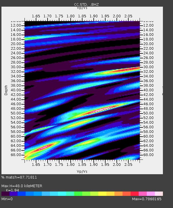
| Estimated Moho Depth: |
48.0 km |
| Estimated Crust Vp/Vs: |
1.94 |
| Assumed Crust Vp: |
6.566 km/s |
| Estimated Crust Vs: |
3.385 km/s |
| Estimated Crust Poisson's Ratio: |
0.32 |
|
| Radial Match: |
87.71811 % |
| Radial Bump: |
400 |
| Transverse Match: |
60.907227 % |
| Transverse Bump: |
400 |
| SOD ConfigId: |
751272 |
| Insert Time: |
2014-07-21 11:47:27.531 +0000 |
| GWidth: |
2.5 |
| Max Bumps: |
400 |
| Tol: |
0.001 |
|

Signal To Noise
| Channel | StoN | STA | LTA |
| CC:STD: :BHZ:20140707T11:30:54.94001Z | 19.184063 | 2.001259E-6 | 1.0431882E-7 |
| CC:STD: :BHN:20140707T11:30:54.94001Z | 1.2017763 | 5.8314225E-7 | 4.852336E-7 |
| CC:STD: :BHE:20140707T11:30:54.94001Z | 1.4662722 | 4.3086987E-7 | 2.9385393E-7 |
| Arrivals |
| Ps | 7.3 SECOND |
| PpPs | 20 SECOND |
| PsPs/PpSs | 27 SECOND |


