You are here: Home > Network List > CH - Switzerland Seismological Network Stations List
> Station SENIN Lac Selin/Sanetsch > Earthquake Result Viewer
SENIN Lac Selin/Sanetsch - Earthquake Result Viewer
| Earthquake location: |
Near Coast Of Chiapas, Mexico |
| Earthquake latitude/longitude: |
14.7/-92.4 |
| Earthquake time(UTC): |
2014/07/07 (188) 11:23:55 GMT |
| Earthquake Depth: |
60 km |
| Earthquake Magnitude: |
6.9 MWW, 6.9 MWC, 7.1 MI |
| Earthquake Catalog/Contributor: |
NEIC PDE/NEIC COMCAT |
|
| Network: |
CH Switzerland Seismological Network |
| Station: |
SENIN Lac Selin/Sanetsch |
| Lat/Lon: |
46.36 N/7.30 E |
| Elevation: |
2035 m |
|
| Distance: |
86.0 deg |
| Az: |
43.176 deg |
| Baz: |
287.069 deg |
| Ray Param: |
0.044242162 |
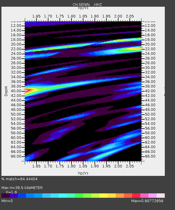
| Estimated Moho Depth: |
39.5 km |
| Estimated Crust Vp/Vs: |
1.60 |
| Assumed Crust Vp: |
6.276 km/s |
| Estimated Crust Vs: |
3.922 km/s |
| Estimated Crust Poisson's Ratio: |
0.18 |
|
| Radial Match: |
94.44404 % |
| Radial Bump: |
304 |
| Transverse Match: |
88.423836 % |
| Transverse Bump: |
399 |
| SOD ConfigId: |
751272 |
| Insert Time: |
2014-07-21 11:48:15.940 +0000 |
| GWidth: |
2.5 |
| Max Bumps: |
400 |
| Tol: |
0.001 |
|

Signal To Noise
| Channel | StoN | STA | LTA |
| CH:SENIN: :HHZ:20140707T11:35:58.221016Z | 43.21906 | 3.8692765E-6 | 8.9527084E-8 |
| CH:SENIN: :HHN:20140707T11:35:58.221016Z | 7.8553567 | 7.3873576E-7 | 9.404229E-8 |
| CH:SENIN: :HHE:20140707T11:35:58.221016Z | 18.573803 | 1.1920107E-6 | 6.417699E-8 |
| Arrivals |
| Ps | 3.9 SECOND |
| PpPs | 16 SECOND |
| PsPs/PpSs | 20 SECOND |


