You are here: Home > Network List > RV - Regional Alberta Seismic Observatory for Earthquake Studies Network Stations List
> Station ATHA Athabasca, AB > Earthquake Result Viewer
ATHA Athabasca, AB - Earthquake Result Viewer
| Earthquake location: |
New Britain Region, P.N.G. |
| Earthquake latitude/longitude: |
-4.7/152.6 |
| Earthquake time(UTC): |
2015/03/29 (088) 23:48:34 GMT |
| Earthquake Depth: |
66 km |
| Earthquake Magnitude: |
7.7 MWP, 7.6 MI |
| Earthquake Catalog/Contributor: |
NEIC PDE/NEIC COMCAT |
|
| Network: |
RV Regional Alberta Seismic Observatory for Earthquake Studies Network |
| Station: |
ATHA Athabasca, AB |
| Lat/Lon: |
54.71 N/113.31 W |
| Elevation: |
569 m |
|
| Distance: |
96.2 deg |
| Az: |
35.604 deg |
| Baz: |
270.618 deg |
| Ray Param: |
0.040530268 |
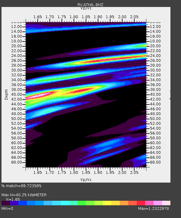
| Estimated Moho Depth: |
40.25 km |
| Estimated Crust Vp/Vs: |
1.65 |
| Assumed Crust Vp: |
6.444 km/s |
| Estimated Crust Vs: |
3.905 km/s |
| Estimated Crust Poisson's Ratio: |
0.21 |
|
| Radial Match: |
89.723595 % |
| Radial Bump: |
283 |
| Transverse Match: |
81.08967 % |
| Transverse Bump: |
400 |
| SOD ConfigId: |
7422571 |
| Insert Time: |
2019-04-17 23:16:17.497 +0000 |
| GWidth: |
2.5 |
| Max Bumps: |
400 |
| Tol: |
0.001 |
|

Signal To Noise
| Channel | StoN | STA | LTA |
| RV:ATHA: :BHZ:20150330T00:01:23.49999Z | 2.7788854 | 8.091631E-7 | 2.9118263E-7 |
| RV:ATHA: :BHN:20150330T00:01:23.49999Z | 0.9453838 | 3.3624528E-7 | 3.556707E-7 |
| RV:ATHA: :BHE:20150330T00:01:23.49999Z | 1.5590317 | 7.2009266E-7 | 4.6188455E-7 |
| Arrivals |
| Ps | 4.1 SECOND |
| PpPs | 16 SECOND |
| PsPs/PpSs | 20 SECOND |


