You are here: Home > Network List > CN - Canadian National Seismograph Network Stations List
> Station ATKO ATIKOKAN IRON MINE, ON > Earthquake Result Viewer
ATKO ATIKOKAN IRON MINE, ON - Earthquake Result Viewer
| Earthquake location: |
Near Coast Of Chiapas, Mexico |
| Earthquake latitude/longitude: |
14.7/-92.4 |
| Earthquake time(UTC): |
2014/07/07 (188) 11:23:55 GMT |
| Earthquake Depth: |
60 km |
| Earthquake Magnitude: |
6.9 MWW, 6.9 MWC, 7.1 MI |
| Earthquake Catalog/Contributor: |
NEIC PDE/NEIC COMCAT |
|
| Network: |
CN Canadian National Seismograph Network |
| Station: |
ATKO ATIKOKAN IRON MINE, ON |
| Lat/Lon: |
48.82 N/91.60 W |
| Elevation: |
383 m |
|
| Distance: |
34.0 deg |
| Az: |
0.956 deg |
| Baz: |
181.399 deg |
| Ray Param: |
0.07781016 |
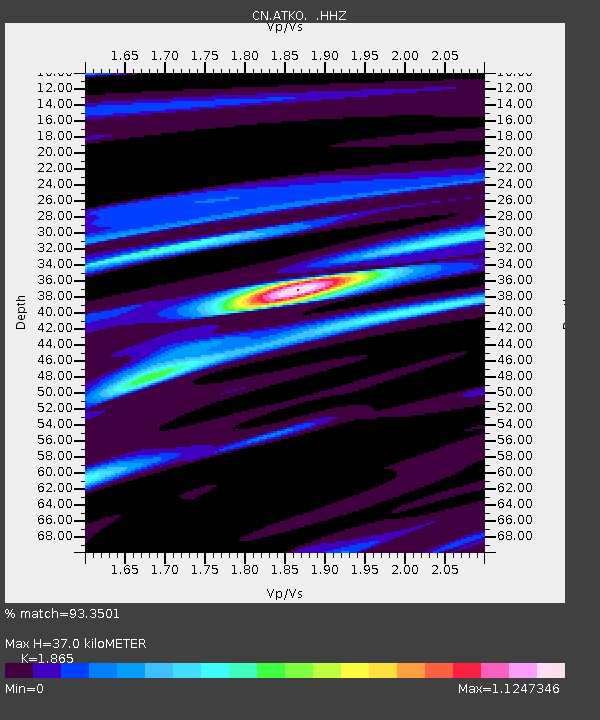
| Estimated Moho Depth: |
37.0 km |
| Estimated Crust Vp/Vs: |
1.87 |
| Assumed Crust Vp: |
6.467 km/s |
| Estimated Crust Vs: |
3.467 km/s |
| Estimated Crust Poisson's Ratio: |
0.30 |
|
| Radial Match: |
93.3501 % |
| Radial Bump: |
223 |
| Transverse Match: |
70.5852 % |
| Transverse Bump: |
400 |
| SOD ConfigId: |
751272 |
| Insert Time: |
2014-07-21 11:49:19.111 +0000 |
| GWidth: |
2.5 |
| Max Bumps: |
400 |
| Tol: |
0.001 |
|

Signal To Noise
| Channel | StoN | STA | LTA |
| CN:ATKO: :HHZ:20140707T11:30:03.079994Z | 43.125153 | 1.819878E-6 | 4.219992E-8 |
| CN:ATKO: :HHN:20140707T11:30:03.079994Z | 43.994194 | 1.0032626E-6 | 2.2804432E-8 |
| CN:ATKO: :HHE:20140707T11:30:03.079994Z | 4.898468 | 1.4148013E-7 | 2.8882523E-8 |
| Arrivals |
| Ps | 5.3 SECOND |
| PpPs | 15 SECOND |
| PsPs/PpSs | 21 SECOND |


