You are here: Home > Network List > RV - Regional Alberta Seismic Observatory for Earthquake Studies Network Stations List
> Station WTMTA White Mountain Lookout Tower, AB > Earthquake Result Viewer
WTMTA White Mountain Lookout Tower, AB - Earthquake Result Viewer
| Earthquake location: |
New Britain Region, P.N.G. |
| Earthquake latitude/longitude: |
-4.7/152.6 |
| Earthquake time(UTC): |
2015/03/29 (088) 23:48:34 GMT |
| Earthquake Depth: |
66 km |
| Earthquake Magnitude: |
7.7 MWP, 7.6 MI |
| Earthquake Catalog/Contributor: |
NEIC PDE/NEIC COMCAT |
|
| Network: |
RV Regional Alberta Seismic Observatory for Earthquake Studies Network |
| Station: |
WTMTA White Mountain Lookout Tower, AB |
| Lat/Lon: |
55.69 N/119.24 W |
| Elevation: |
1030 m |
|
| Distance: |
92.9 deg |
| Az: |
34.515 deg |
| Baz: |
265.847 deg |
| Ray Param: |
0.04134212 |
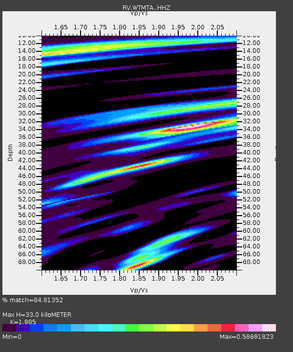
| Estimated Moho Depth: |
33.0 km |
| Estimated Crust Vp/Vs: |
1.99 |
| Assumed Crust Vp: |
6.161 km/s |
| Estimated Crust Vs: |
3.104 km/s |
| Estimated Crust Poisson's Ratio: |
0.33 |
|
| Radial Match: |
84.81352 % |
| Radial Bump: |
400 |
| Transverse Match: |
64.78788 % |
| Transverse Bump: |
400 |
| SOD ConfigId: |
7422571 |
| Insert Time: |
2019-04-17 23:16:24.766 +0000 |
| GWidth: |
2.5 |
| Max Bumps: |
400 |
| Tol: |
0.001 |
|

Signal To Noise
| Channel | StoN | STA | LTA |
| RV:WTMTA: :HHZ:20150330T00:01:08.189993Z | 3.800316 | 1.2228915E-6 | 3.2178676E-7 |
| RV:WTMTA: :HHN:20150330T00:01:08.189993Z | 0.7026771 | 4.1370063E-7 | 5.887493E-7 |
| RV:WTMTA: :HHE:20150330T00:01:08.189993Z | 0.9748683 | 5.487032E-7 | 5.628485E-7 |
| Arrivals |
| Ps | 5.4 SECOND |
| PpPs | 16 SECOND |
| PsPs/PpSs | 21 SECOND |


