You are here: Home > Network List > TA - USArray Transportable Network (new EarthScope stations) Stations List
> Station D03D Eldon, WA, USA > Earthquake Result Viewer
D03D Eldon, WA, USA - Earthquake Result Viewer
| Earthquake location: |
New Britain Region, P.N.G. |
| Earthquake latitude/longitude: |
-4.7/152.6 |
| Earthquake time(UTC): |
2015/03/29 (088) 23:48:34 GMT |
| Earthquake Depth: |
66 km |
| Earthquake Magnitude: |
7.7 MWP, 7.6 MI |
| Earthquake Catalog/Contributor: |
NEIC PDE/NEIC COMCAT |
|
| Network: |
TA USArray Transportable Network (new EarthScope stations) |
| Station: |
D03D Eldon, WA, USA |
| Lat/Lon: |
47.53 N/123.09 W |
| Elevation: |
262 m |
|
| Distance: |
89.7 deg |
| Az: |
42.402 deg |
| Baz: |
262.655 deg |
| Ray Param: |
0.04171782 |
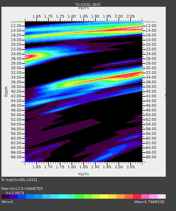
| Estimated Moho Depth: |
12.5 km |
| Estimated Crust Vp/Vs: |
2.10 |
| Assumed Crust Vp: |
6.566 km/s |
| Estimated Crust Vs: |
3.13 km/s |
| Estimated Crust Poisson's Ratio: |
0.35 |
|
| Radial Match: |
95.10421 % |
| Radial Bump: |
400 |
| Transverse Match: |
82.88028 % |
| Transverse Bump: |
397 |
| SOD ConfigId: |
7422571 |
| Insert Time: |
2019-04-17 23:16:36.099 +0000 |
| GWidth: |
2.5 |
| Max Bumps: |
400 |
| Tol: |
0.001 |
|

Signal To Noise
| Channel | StoN | STA | LTA |
| TA:D03D: :BHZ:20150330T00:00:53.350027Z | 3.341017 | 1.0821404E-6 | 3.238955E-7 |
| TA:D03D: :BHN:20150330T00:00:53.350027Z | 1.2200241 | 5.805753E-7 | 4.7587199E-7 |
| TA:D03D: :BHE:20150330T00:00:53.350027Z | 2.8627682 | 5.345561E-7 | 1.86727E-7 |
| Arrivals |
| Ps | 2.1 SECOND |
| PpPs | 5.8 SECOND |
| PsPs/PpSs | 7.9 SECOND |


