You are here: Home > Network List > TA - USArray Transportable Network (new EarthScope stations) Stations List
> Station M04C Macdoel, CA, USA > Earthquake Result Viewer
M04C Macdoel, CA, USA - Earthquake Result Viewer
| Earthquake location: |
New Britain Region, P.N.G. |
| Earthquake latitude/longitude: |
-4.7/152.6 |
| Earthquake time(UTC): |
2015/03/29 (088) 23:48:34 GMT |
| Earthquake Depth: |
66 km |
| Earthquake Magnitude: |
7.7 MWP, 7.6 MI |
| Earthquake Catalog/Contributor: |
NEIC PDE/NEIC COMCAT |
|
| Network: |
TA USArray Transportable Network (new EarthScope stations) |
| Station: |
M04C Macdoel, CA, USA |
| Lat/Lon: |
41.78 N/121.84 W |
| Elevation: |
1391 m |
|
| Distance: |
89.8 deg |
| Az: |
48.219 deg |
| Baz: |
263.557 deg |
| Ray Param: |
0.04170385 |
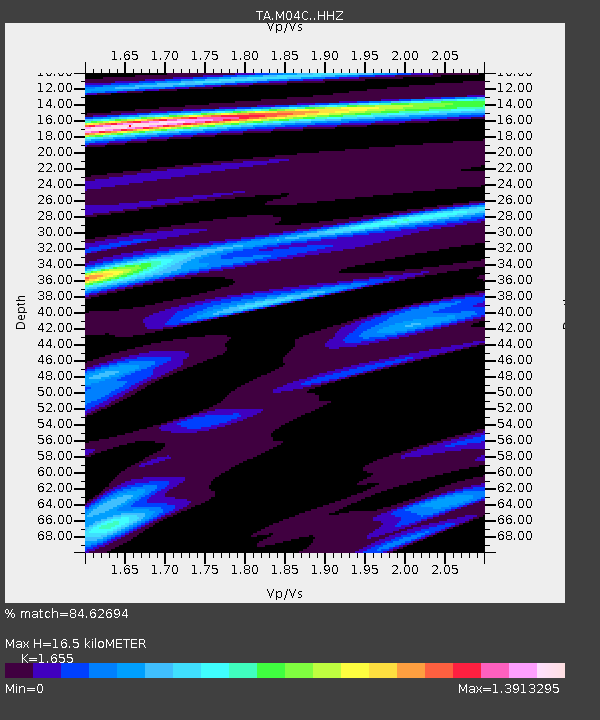
| Estimated Moho Depth: |
16.5 km |
| Estimated Crust Vp/Vs: |
1.65 |
| Assumed Crust Vp: |
6.566 km/s |
| Estimated Crust Vs: |
3.967 km/s |
| Estimated Crust Poisson's Ratio: |
0.21 |
|
| Radial Match: |
84.62694 % |
| Radial Bump: |
400 |
| Transverse Match: |
58.555702 % |
| Transverse Bump: |
400 |
| SOD ConfigId: |
7422571 |
| Insert Time: |
2019-04-17 23:16:48.840 +0000 |
| GWidth: |
2.5 |
| Max Bumps: |
400 |
| Tol: |
0.001 |
|

Signal To Noise
| Channel | StoN | STA | LTA |
| TA:M04C: :HHZ:20150330T00:00:54.229971Z | 4.4919486 | 8.9179383E-7 | 1.9853161E-7 |
| TA:M04C: :HHN:20150330T00:00:54.229971Z | 0.5492779 | 4.0014555E-7 | 7.284938E-7 |
| TA:M04C: :HHE:20150330T00:00:54.229971Z | 0.41031283 | 3.5150097E-7 | 8.566658E-7 |
| Arrivals |
| Ps | 1.7 SECOND |
| PpPs | 6.5 SECOND |
| PsPs/PpSs | 8.2 SECOND |


