You are here: Home > Network List > G - GEOSCOPE Stations List
> Station CLF Chambon la Foret observatory, France > Earthquake Result Viewer
CLF Chambon la Foret observatory, France - Earthquake Result Viewer
| Earthquake location: |
Near Coast Of Chiapas, Mexico |
| Earthquake latitude/longitude: |
14.7/-92.4 |
| Earthquake time(UTC): |
2014/07/07 (188) 11:23:55 GMT |
| Earthquake Depth: |
60 km |
| Earthquake Magnitude: |
6.9 MWW, 6.9 MWC, 7.1 MI |
| Earthquake Catalog/Contributor: |
NEIC PDE/NEIC COMCAT |
|
| Network: |
G GEOSCOPE |
| Station: |
CLF Chambon la Foret observatory, France |
| Lat/Lon: |
48.03 N/2.26 E |
| Elevation: |
145 m |
|
| Distance: |
82.3 deg |
| Az: |
42.469 deg |
| Baz: |
283.309 deg |
| Ray Param: |
0.046893697 |
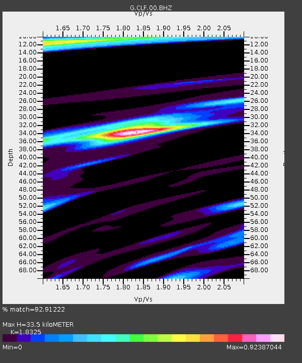
| Estimated Moho Depth: |
33.5 km |
| Estimated Crust Vp/Vs: |
1.83 |
| Assumed Crust Vp: |
6.12 km/s |
| Estimated Crust Vs: |
3.34 km/s |
| Estimated Crust Poisson's Ratio: |
0.29 |
|
| Radial Match: |
92.91222 % |
| Radial Bump: |
400 |
| Transverse Match: |
68.25645 % |
| Transverse Bump: |
400 |
| SOD ConfigId: |
751272 |
| Insert Time: |
2014-07-21 11:52:23.994 +0000 |
| GWidth: |
2.5 |
| Max Bumps: |
400 |
| Tol: |
0.001 |
|
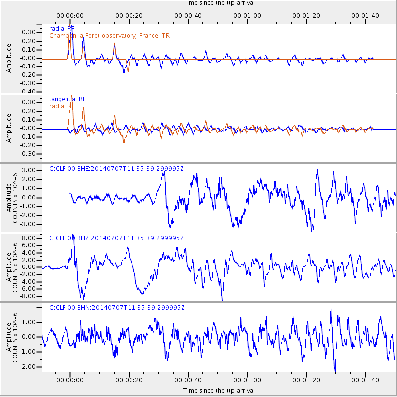
Signal To Noise
| Channel | StoN | STA | LTA |
| G:CLF:00:BHZ:20140707T11:35:39.299995Z | 17.185246 | 5.411762E-6 | 3.1490742E-7 |
| G:CLF:00:BHN:20140707T11:35:39.299995Z | 1.2033628 | 4.4672603E-7 | 3.7123138E-7 |
| G:CLF:00:BHE:20140707T11:35:39.299995Z | 7.36653 | 2.0355546E-6 | 2.7632476E-7 |
| Arrivals |
| Ps | 4.7 SECOND |
| PpPs | 15 SECOND |
| PsPs/PpSs | 20 SECOND |


