You are here: Home > Network List > TO - Tectonic Observatory Stations List
> Station CC33 CCSE CC33 > Earthquake Result Viewer
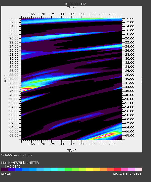
CC33 CCSE CC33 - Earthquake Result Viewer
| Earthquake location: |
New Britain Region, P.N.G. |
| Earthquake latitude/longitude: |
-4.7/152.6 |
| Earthquake time(UTC): |
2015/03/29 (088) 23:48:34 GMT |
| Earthquake Depth: |
66 km |
| Earthquake Magnitude: |
7.7 MWP, 7.6 MI |
| Earthquake Catalog/Contributor: |
NEIC PDE/NEIC COMCAT |
|
| Network: |
TO Tectonic Observatory |
| Station: |
CC33 CCSE CC33 |
| Lat/Lon: |
36.34 N/119.12 W |
| Elevation: |
126 m |
|
| Distance: |
91.4 deg |
| Az: |
53.83 deg |
| Baz: |
265.202 deg |
| Ray Param: |
0.041587416 |
| Estimated Moho Depth: |
67.75 km |
| Estimated Crust Vp/Vs: |
2.02 |
| Assumed Crust Vp: |
6.291 km/s |
| Estimated Crust Vs: |
3.118 km/s |
| Estimated Crust Poisson's Ratio: |
0.34 |
|
| Radial Match: |
95.91852 % |
| Radial Bump: |
196 |
| Transverse Match: |
75.5767 % |
| Transverse Bump: |
400 |
| SOD ConfigId: |
7422571 |
| Insert Time: |
2019-04-17 23:17:16.799 +0000 |
| GWidth: |
2.5 |
| Max Bumps: |
400 |
| Tol: |
0.001 |
|

Signal To Noise
| Channel | StoN | STA | LTA |
| TO:CC33: :HHZ:20150330T00:01:01.49999Z | 4.4560637 | 8.961722E-7 | 2.0111297E-7 |
| TO:CC33: :HHN:20150330T00:01:01.49999Z | 1.5403186 | 1.8235349E-7 | 1.1838686E-7 |
| TO:CC33: :HHE:20150330T00:01:01.49999Z | 2.7020268 | 3.5537232E-7 | 1.3152064E-7 |
| Arrivals |
| Ps | 11 SECOND |
| PpPs | 32 SECOND |
| PsPs/PpSs | 43 SECOND |


