You are here: Home > Network List > TO - Tectonic Observatory Stations List
> Station CC38 CCSE CC38 > Earthquake Result Viewer
CC38 CCSE CC38 - Earthquake Result Viewer
| Earthquake location: |
New Britain Region, P.N.G. |
| Earthquake latitude/longitude: |
-4.7/152.6 |
| Earthquake time(UTC): |
2015/03/29 (088) 23:48:34 GMT |
| Earthquake Depth: |
66 km |
| Earthquake Magnitude: |
7.7 MWP, 7.6 MI |
| Earthquake Catalog/Contributor: |
NEIC PDE/NEIC COMCAT |
|
| Network: |
TO Tectonic Observatory |
| Station: |
CC38 CCSE CC38 |
| Lat/Lon: |
36.38 N/118.84 W |
| Elevation: |
755 m |
|
| Distance: |
91.7 deg |
| Az: |
53.811 deg |
| Baz: |
265.369 deg |
| Ray Param: |
0.041552674 |
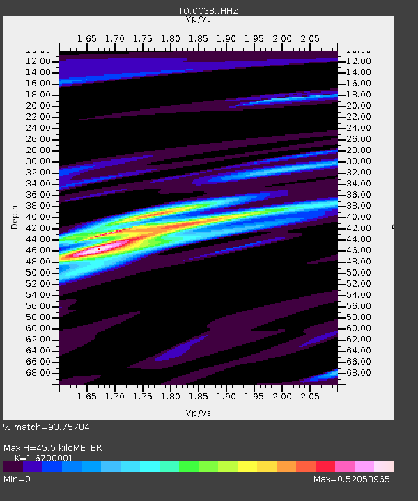
| Estimated Moho Depth: |
45.5 km |
| Estimated Crust Vp/Vs: |
1.67 |
| Assumed Crust Vp: |
6.291 km/s |
| Estimated Crust Vs: |
3.767 km/s |
| Estimated Crust Poisson's Ratio: |
0.22 |
|
| Radial Match: |
93.75784 % |
| Radial Bump: |
238 |
| Transverse Match: |
79.61501 % |
| Transverse Bump: |
400 |
| SOD ConfigId: |
7422571 |
| Insert Time: |
2019-04-17 23:17:18.959 +0000 |
| GWidth: |
2.5 |
| Max Bumps: |
400 |
| Tol: |
0.001 |
|

Signal To Noise
| Channel | StoN | STA | LTA |
| TO:CC38: :HHZ:20150330T00:01:02.559988Z | 2.9126093 | 5.697634E-7 | 1.9561958E-7 |
| TO:CC38: :HHN:20150330T00:01:02.559988Z | 1.2858263 | 1.608476E-7 | 1.250928E-7 |
| TO:CC38: :HHE:20150330T00:01:02.559988Z | 1.4614618 | 2.4470648E-7 | 1.6743952E-7 |
| Arrivals |
| Ps | 4.9 SECOND |
| PpPs | 19 SECOND |
| PsPs/PpSs | 24 SECOND |


