You are here: Home > Network List > GE - GEOFON Stations List
> Station SUMG GEOFON Station Summit Camp, Greenland > Earthquake Result Viewer
SUMG GEOFON Station Summit Camp, Greenland - Earthquake Result Viewer
| Earthquake location: |
Near Coast Of Chiapas, Mexico |
| Earthquake latitude/longitude: |
14.7/-92.4 |
| Earthquake time(UTC): |
2014/07/07 (188) 11:23:55 GMT |
| Earthquake Depth: |
60 km |
| Earthquake Magnitude: |
6.9 MWW, 6.9 MWC, 7.1 MI |
| Earthquake Catalog/Contributor: |
NEIC PDE/NEIC COMCAT |
|
| Network: |
GE GEOFON |
| Station: |
SUMG GEOFON Station Summit Camp, Greenland |
| Lat/Lon: |
72.57 N/38.46 W |
| Elevation: |
3200 m |
|
| Distance: |
65.6 deg |
| Az: |
15.512 deg |
| Baz: |
239.175 deg |
| Ray Param: |
0.058011226 |
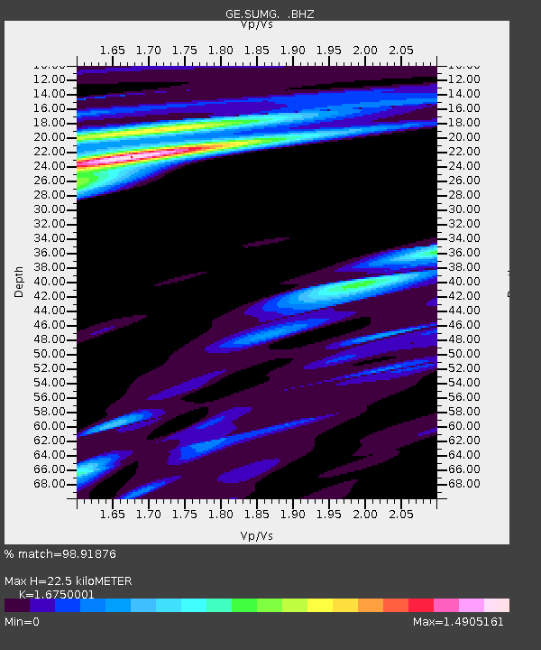
| Estimated Moho Depth: |
22.5 km |
| Estimated Crust Vp/Vs: |
1.68 |
| Assumed Crust Vp: |
6.261 km/s |
| Estimated Crust Vs: |
3.738 km/s |
| Estimated Crust Poisson's Ratio: |
0.22 |
|
| Radial Match: |
98.91876 % |
| Radial Bump: |
368 |
| Transverse Match: |
89.42245 % |
| Transverse Bump: |
400 |
| SOD ConfigId: |
751272 |
| Insert Time: |
2014-07-21 11:53:58.015 +0000 |
| GWidth: |
2.5 |
| Max Bumps: |
400 |
| Tol: |
0.001 |
|

Signal To Noise
| Channel | StoN | STA | LTA |
| GE:SUMG: :BHZ:20140707T11:34:02.445015Z | 57.920532 | 7.867668E-6 | 1.3583555E-7 |
| GE:SUMG: :BHN:20140707T11:34:02.445015Z | 8.248924 | 1.1733329E-6 | 1.4224071E-7 |
| GE:SUMG: :BHE:20140707T11:34:02.445015Z | 29.119612 | 2.6688056E-6 | 9.164977E-8 |
| Arrivals |
| Ps | 2.5 SECOND |
| PpPs | 9.2 SECOND |
| PsPs/PpSs | 12 SECOND |


