You are here: Home > Network List > GT - Global Telemetered Seismograph Network (USAF/USGS) Stations List
> Station DBIC Dimbokro, Cote d'Ivoire > Earthquake Result Viewer
DBIC Dimbokro, Cote d'Ivoire - Earthquake Result Viewer
| Earthquake location: |
Near Coast Of Chiapas, Mexico |
| Earthquake latitude/longitude: |
14.7/-92.4 |
| Earthquake time(UTC): |
2014/07/07 (188) 11:23:55 GMT |
| Earthquake Depth: |
60 km |
| Earthquake Magnitude: |
6.9 MWW, 6.9 MWC, 7.1 MI |
| Earthquake Catalog/Contributor: |
NEIC PDE/NEIC COMCAT |
|
| Network: |
GT Global Telemetered Seismograph Network (USAF/USGS) |
| Station: |
DBIC Dimbokro, Cote d'Ivoire |
| Lat/Lon: |
6.67 N/4.86 W |
| Elevation: |
125 m |
|
| Distance: |
86.0 deg |
| Az: |
84.194 deg |
| Baz: |
284.301 deg |
| Ray Param: |
0.04427387 |
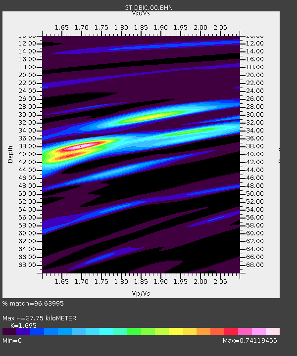
| Estimated Moho Depth: |
37.75 km |
| Estimated Crust Vp/Vs: |
1.70 |
| Assumed Crust Vp: |
6.419 km/s |
| Estimated Crust Vs: |
3.787 km/s |
| Estimated Crust Poisson's Ratio: |
0.23 |
|
| Radial Match: |
96.63995 % |
| Radial Bump: |
282 |
| Transverse Match: |
86.24349 % |
| Transverse Bump: |
400 |
| SOD ConfigId: |
751272 |
| Insert Time: |
2014-07-21 11:54:29.281 +0000 |
| GWidth: |
2.5 |
| Max Bumps: |
400 |
| Tol: |
0.001 |
|
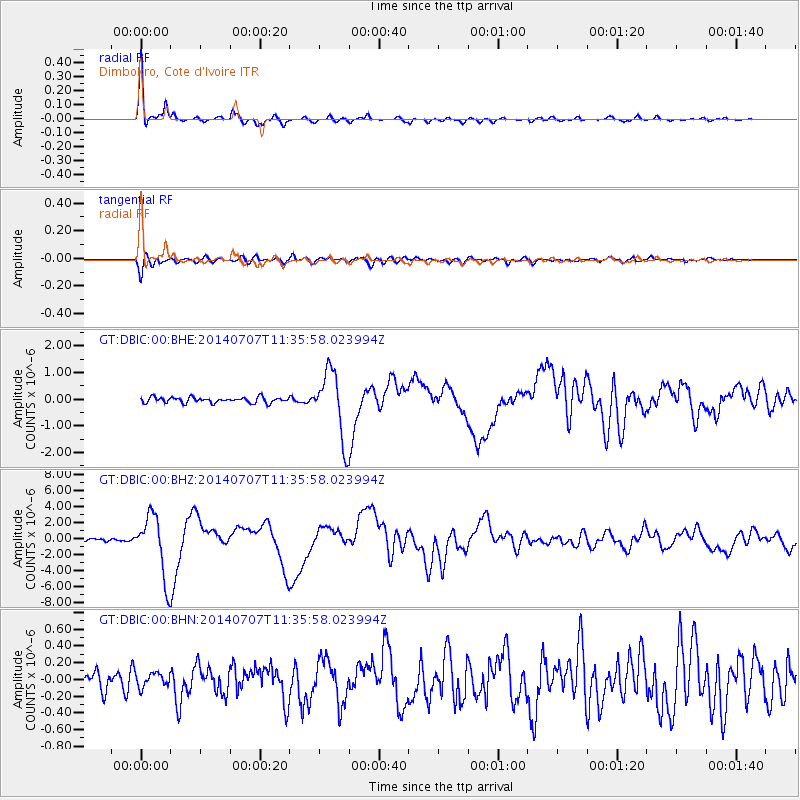
Signal To Noise
| Channel | StoN | STA | LTA |
| GT:DBIC:00:BHZ:20140707T11:35:58.023994Z | 24.261198 | 3.8718626E-6 | 1.5959074E-7 |
| GT:DBIC:00:BHN:20140707T11:35:58.023994Z | 0.71793276 | 8.4934335E-8 | 1.1830402E-7 |
| GT:DBIC:00:BHE:20140707T11:35:58.023994Z | 12.056768 | 1.2661532E-6 | 1.0501596E-7 |
| Arrivals |
| Ps | 4.2 SECOND |
| PpPs | 15 SECOND |
| PsPs/PpSs | 20 SECOND |


