You are here: Home > Network List > XD14 - Illuminating the architecture of the greater Mount St. Helens magmatic systems f Stations List
> Station MB05 "Mount St Helens, WA" > Earthquake Result Viewer
MB05 "Mount St Helens, WA" - Earthquake Result Viewer
| Earthquake location: |
New Britain Region, P.N.G. |
| Earthquake latitude/longitude: |
-4.7/152.6 |
| Earthquake time(UTC): |
2015/03/29 (088) 23:48:34 GMT |
| Earthquake Depth: |
66 km |
| Earthquake Magnitude: |
7.7 MWP, 7.6 MI |
| Earthquake Catalog/Contributor: |
NEIC PDE/NEIC COMCAT |
|
| Network: |
XD Illuminating the architecture of the greater Mount St. Helens magmatic systems f |
| Station: |
MB05 "Mount St Helens, WA" |
| Lat/Lon: |
46.62 N/122.28 W |
| Elevation: |
641 m |
|
| Distance: |
90.1 deg |
| Az: |
43.377 deg |
| Baz: |
263.247 deg |
| Ray Param: |
0.04168672 |
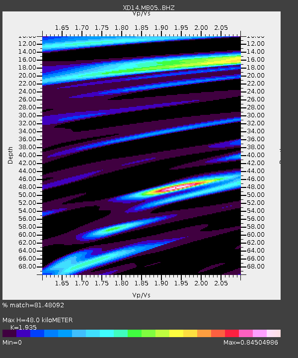
| Estimated Moho Depth: |
48.0 km |
| Estimated Crust Vp/Vs: |
1.93 |
| Assumed Crust Vp: |
6.566 km/s |
| Estimated Crust Vs: |
3.393 km/s |
| Estimated Crust Poisson's Ratio: |
0.32 |
|
| Radial Match: |
81.48092 % |
| Radial Bump: |
400 |
| Transverse Match: |
66.757095 % |
| Transverse Bump: |
400 |
| SOD ConfigId: |
7422571 |
| Insert Time: |
2019-04-17 23:17:56.406 +0000 |
| GWidth: |
2.5 |
| Max Bumps: |
400 |
| Tol: |
0.001 |
|

Signal To Noise
| Channel | StoN | STA | LTA |
| XD:MB05: :BHZ:20150330T00:00:55.369985Z | 2.2274601 | 9.933328E-7 | 4.4594864E-7 |
| XD:MB05: :BHN:20150330T00:00:55.369985Z | 0.9399813 | 3.8048742E-7 | 4.047819E-7 |
| XD:MB05: :BHE:20150330T00:00:55.369985Z | 0.82749027 | 5.0059305E-7 | 6.049534E-7 |
| Arrivals |
| Ps | 7.0 SECOND |
| PpPs | 21 SECOND |
| PsPs/PpSs | 28 SECOND |


