You are here: Home > Network List > XD14 - Illuminating the architecture of the greater Mount St. Helens magmatic systems f Stations List
> Station MK11 "Mount St Helens, WA" > Earthquake Result Viewer
MK11 "Mount St Helens, WA" - Earthquake Result Viewer
| Earthquake location: |
New Britain Region, P.N.G. |
| Earthquake latitude/longitude: |
-4.7/152.6 |
| Earthquake time(UTC): |
2015/03/29 (088) 23:48:34 GMT |
| Earthquake Depth: |
66 km |
| Earthquake Magnitude: |
7.7 MWP, 7.6 MI |
| Earthquake Catalog/Contributor: |
NEIC PDE/NEIC COMCAT |
|
| Network: |
XD Illuminating the architecture of the greater Mount St. Helens magmatic systems f |
| Station: |
MK11 "Mount St Helens, WA" |
| Lat/Lon: |
46.15 N/121.60 W |
| Elevation: |
1343 m |
|
| Distance: |
90.5 deg |
| Az: |
43.896 deg |
| Baz: |
263.735 deg |
| Ray Param: |
0.041657206 |
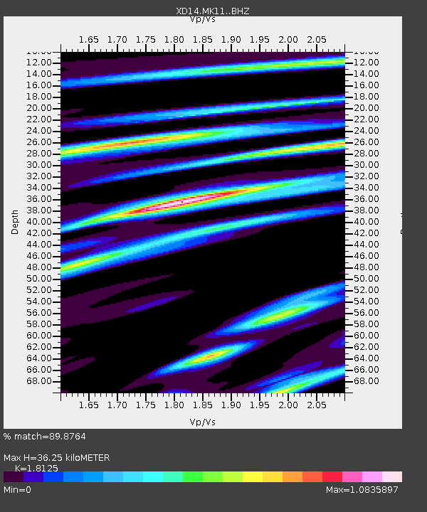
| Estimated Moho Depth: |
36.25 km |
| Estimated Crust Vp/Vs: |
1.81 |
| Assumed Crust Vp: |
6.597 km/s |
| Estimated Crust Vs: |
3.64 km/s |
| Estimated Crust Poisson's Ratio: |
0.28 |
|
| Radial Match: |
89.8764 % |
| Radial Bump: |
400 |
| Transverse Match: |
68.05537 % |
| Transverse Bump: |
400 |
| SOD ConfigId: |
7422571 |
| Insert Time: |
2019-04-17 23:18:26.424 +0000 |
| GWidth: |
2.5 |
| Max Bumps: |
400 |
| Tol: |
0.001 |
|

Signal To Noise
| Channel | StoN | STA | LTA |
| XD:MK11: :BHZ:20150330T00:00:57.285024Z | 6.9564953 | 1.1282606E-6 | 1.6218809E-7 |
| XD:MK11: :BHN:20150330T00:00:57.285024Z | 0.7200822 | 2.1405152E-7 | 2.9725985E-7 |
| XD:MK11: :BHE:20150330T00:00:57.285024Z | 1.977828 | 4.2258944E-7 | 2.1366338E-7 |
| Arrivals |
| Ps | 4.6 SECOND |
| PpPs | 15 SECOND |
| PsPs/PpSs | 20 SECOND |


