You are here: Home > Network List > IU - Global Seismograph Network (GSN - IRIS/USGS) Stations List
> Station POHA Pohakuloa, Hawaii, USA > Earthquake Result Viewer
POHA Pohakuloa, Hawaii, USA - Earthquake Result Viewer
| Earthquake location: |
Near Coast Of Chiapas, Mexico |
| Earthquake latitude/longitude: |
14.7/-92.4 |
| Earthquake time(UTC): |
2014/07/07 (188) 11:23:55 GMT |
| Earthquake Depth: |
60 km |
| Earthquake Magnitude: |
6.9 MWW, 6.9 MWC, 7.1 MI |
| Earthquake Catalog/Contributor: |
NEIC PDE/NEIC COMCAT |
|
| Network: |
IU Global Seismograph Network (GSN - IRIS/USGS) |
| Station: |
POHA Pohakuloa, Hawaii, USA |
| Lat/Lon: |
19.76 N/155.53 W |
| Elevation: |
1990 m |
|
| Distance: |
60.2 deg |
| Az: |
284.511 deg |
| Baz: |
83.968 deg |
| Ray Param: |
0.061538883 |
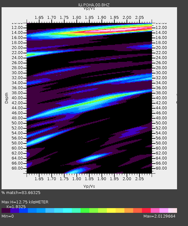
| Estimated Moho Depth: |
12.75 km |
| Estimated Crust Vp/Vs: |
1.93 |
| Assumed Crust Vp: |
5.195 km/s |
| Estimated Crust Vs: |
2.688 km/s |
| Estimated Crust Poisson's Ratio: |
0.32 |
|
| Radial Match: |
83.66325 % |
| Radial Bump: |
400 |
| Transverse Match: |
71.898865 % |
| Transverse Bump: |
400 |
| SOD ConfigId: |
751272 |
| Insert Time: |
2014-07-21 11:58:08.508 +0000 |
| GWidth: |
2.5 |
| Max Bumps: |
400 |
| Tol: |
0.001 |
|
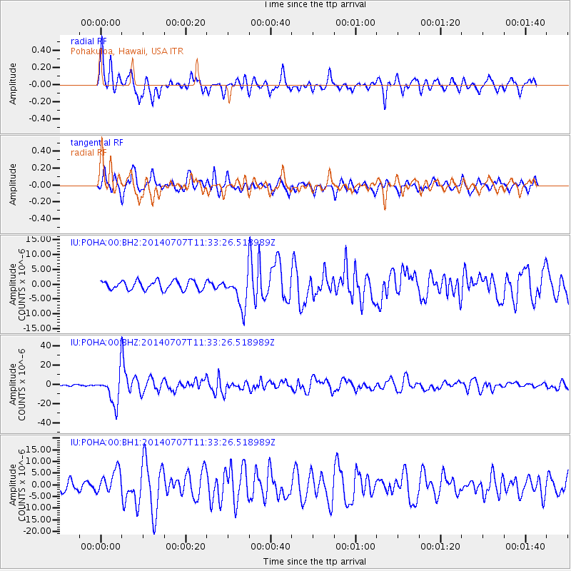
Signal To Noise
| Channel | StoN | STA | LTA |
| IU:POHA:00:BHZ:20140707T11:33:26.518989Z | 26.485987 | 1.672757E-5 | 6.3156307E-7 |
| IU:POHA:00:BH1:20140707T11:33:26.518989Z | 2.3096688 | 5.068752E-6 | 2.1945796E-6 |
| IU:POHA:00:BH2:20140707T11:33:26.518989Z | 3.6827545 | 5.584547E-6 | 1.516405E-6 |
| Arrivals |
| Ps | 2.4 SECOND |
| PpPs | 7.0 SECOND |
| PsPs/PpSs | 9.4 SECOND |


