You are here: Home > Network List > LD - Lamont-Doherty Cooperative Seismographic Network Stations List
> Station KSPA Keystone College, La Plume, PA > Earthquake Result Viewer
KSPA Keystone College, La Plume, PA - Earthquake Result Viewer
| Earthquake location: |
Near Coast Of Chiapas, Mexico |
| Earthquake latitude/longitude: |
14.7/-92.4 |
| Earthquake time(UTC): |
2014/07/07 (188) 11:23:55 GMT |
| Earthquake Depth: |
60 km |
| Earthquake Magnitude: |
6.9 MWW, 6.9 MWC, 7.1 MI |
| Earthquake Catalog/Contributor: |
NEIC PDE/NEIC COMCAT |
|
| Network: |
LD Lamont-Doherty Cooperative Seismographic Network |
| Station: |
KSPA Keystone College, La Plume, PA |
| Lat/Lon: |
41.56 N/75.77 W |
| Elevation: |
298 m |
|
| Distance: |
30.4 deg |
| Az: |
25.16 deg |
| Baz: |
213.235 deg |
| Ray Param: |
0.07926732 |
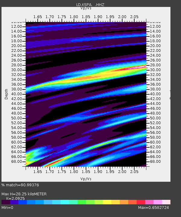
| Estimated Moho Depth: |
28.25 km |
| Estimated Crust Vp/Vs: |
2.09 |
| Assumed Crust Vp: |
6.283 km/s |
| Estimated Crust Vs: |
3.003 km/s |
| Estimated Crust Poisson's Ratio: |
0.35 |
|
| Radial Match: |
90.99376 % |
| Radial Bump: |
270 |
| Transverse Match: |
80.446495 % |
| Transverse Bump: |
341 |
| SOD ConfigId: |
751272 |
| Insert Time: |
2014-07-21 12:00:12.454 +0000 |
| GWidth: |
2.5 |
| Max Bumps: |
400 |
| Tol: |
0.001 |
|

Signal To Noise
| Channel | StoN | STA | LTA |
| LD:KSPA: :HHZ:20140707T11:29:31.410011Z | 45.084667 | 9.928853E-6 | 2.2022681E-7 |
| LD:KSPA: :HHN:20140707T11:29:31.410011Z | 29.15153 | 4.3023524E-6 | 1.4758584E-7 |
| LD:KSPA: :HHE:20140707T11:29:31.410011Z | 24.094723 | 3.8251283E-6 | 1.5875378E-7 |
| Arrivals |
| Ps | 5.2 SECOND |
| PpPs | 13 SECOND |
| PsPs/PpSs | 18 SECOND |


