You are here: Home > Network List > Y506 - Canadian Rockies and Alberta Network Stations List
> Station PER CRANE station near Peers AB > Earthquake Result Viewer
PER CRANE station near Peers AB - Earthquake Result Viewer
| Earthquake location: |
New Britain Region, P.N.G. |
| Earthquake latitude/longitude: |
-4.7/152.6 |
| Earthquake time(UTC): |
2015/03/29 (088) 23:48:34 GMT |
| Earthquake Depth: |
66 km |
| Earthquake Magnitude: |
7.7 MWP, 7.6 MI |
| Earthquake Catalog/Contributor: |
NEIC PDE/NEIC COMCAT |
|
| Network: |
Y5 Canadian Rockies and Alberta Network |
| Station: |
PER CRANE station near Peers AB |
| Lat/Lon: |
53.68 N/116.04 W |
| Elevation: |
849 m |
|
| Distance: |
94.6 deg |
| Az: |
36.627 deg |
| Baz: |
268.313 deg |
| Ray Param: |
0.04095804 |
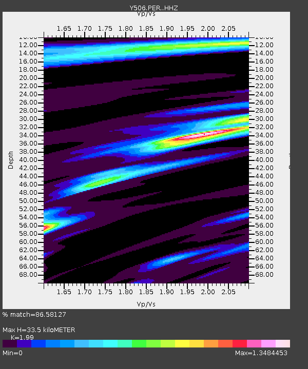
| Estimated Moho Depth: |
33.5 km |
| Estimated Crust Vp/Vs: |
1.99 |
| Assumed Crust Vp: |
6.142 km/s |
| Estimated Crust Vs: |
3.086 km/s |
| Estimated Crust Poisson's Ratio: |
0.33 |
|
| Radial Match: |
86.58127 % |
| Radial Bump: |
299 |
| Transverse Match: |
71.20579 % |
| Transverse Bump: |
400 |
| SOD ConfigId: |
7422571 |
| Insert Time: |
2019-04-17 23:19:14.238 +0000 |
| GWidth: |
2.5 |
| Max Bumps: |
400 |
| Tol: |
0.001 |
|

Signal To Noise
| Channel | StoN | STA | LTA |
| Y5:PER: :HHZ:20150330T00:01:16.189993Z | 3.2091937 | 9.0715963E-7 | 2.8267524E-7 |
| Y5:PER: :HHN:20150330T00:01:16.189993Z | 0.66059846 | 3.7900523E-7 | 5.737301E-7 |
| Y5:PER: :HHE:20150330T00:01:16.189993Z | 0.44145572 | 3.7065666E-7 | 8.396237E-7 |
| Arrivals |
| Ps | 5.5 SECOND |
| PpPs | 16 SECOND |
| PsPs/PpSs | 22 SECOND |


