You are here: Home > Network List > NE - New England Seismic Network Stations List
> Station HNH Hanover, NH, USA > Earthquake Result Viewer
HNH Hanover, NH, USA - Earthquake Result Viewer
| Earthquake location: |
Near Coast Of Chiapas, Mexico |
| Earthquake latitude/longitude: |
14.7/-92.4 |
| Earthquake time(UTC): |
2014/07/07 (188) 11:23:55 GMT |
| Earthquake Depth: |
60 km |
| Earthquake Magnitude: |
6.9 MWW, 6.9 MWC, 7.1 MI |
| Earthquake Catalog/Contributor: |
NEIC PDE/NEIC COMCAT |
|
| Network: |
NE New England Seismic Network |
| Station: |
HNH Hanover, NH, USA |
| Lat/Lon: |
43.71 N/72.29 W |
| Elevation: |
180 m |
|
| Distance: |
33.6 deg |
| Az: |
26.798 deg |
| Baz: |
216.976 deg |
| Ray Param: |
0.077990144 |
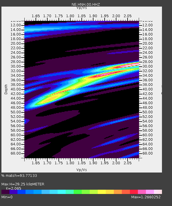
| Estimated Moho Depth: |
29.25 km |
| Estimated Crust Vp/Vs: |
2.07 |
| Assumed Crust Vp: |
6.419 km/s |
| Estimated Crust Vs: |
3.109 km/s |
| Estimated Crust Poisson's Ratio: |
0.35 |
|
| Radial Match: |
93.77133 % |
| Radial Bump: |
162 |
| Transverse Match: |
83.474144 % |
| Transverse Bump: |
297 |
| SOD ConfigId: |
751272 |
| Insert Time: |
2014-07-21 12:02:34.443 +0000 |
| GWidth: |
2.5 |
| Max Bumps: |
400 |
| Tol: |
0.001 |
|

Signal To Noise
| Channel | StoN | STA | LTA |
| NE:HNH:00:HHZ:20140707T11:29:59.689003Z | 45.68381 | 7.202406E-6 | 1.5765772E-7 |
| NE:HNH:00:HH1:20140707T11:29:59.689003Z | 27.17806 | 4.2870706E-6 | 1.5774013E-7 |
| NE:HNH:00:HH2:20140707T11:29:59.689003Z | 10.186014 | 1.0263171E-6 | 1.0075749E-7 |
| Arrivals |
| Ps | 5.2 SECOND |
| PpPs | 13 SECOND |
| PsPs/PpSs | 18 SECOND |


