You are here: Home > Network List > YT07 - POLENET Stations List
> Station HOWD HOWD > Earthquake Result Viewer
HOWD HOWD - Earthquake Result Viewer
| Earthquake location: |
New Britain Region, P.N.G. |
| Earthquake latitude/longitude: |
-4.7/152.6 |
| Earthquake time(UTC): |
2015/03/29 (088) 23:48:34 GMT |
| Earthquake Depth: |
66 km |
| Earthquake Magnitude: |
7.7 MWP, 7.6 MI |
| Earthquake Catalog/Contributor: |
NEIC PDE/NEIC COMCAT |
|
| Network: |
YT POLENET |
| Station: |
HOWD HOWD |
| Lat/Lon: |
77.53 S/86.77 W |
| Elevation: |
1495 m |
|
| Distance: |
91.7 deg |
| Az: |
169.221 deg |
| Baz: |
239.048 deg |
| Ray Param: |
0.041540507 |
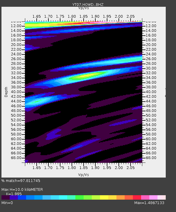
| Estimated Moho Depth: |
10.0 km |
| Estimated Crust Vp/Vs: |
2.00 |
| Assumed Crust Vp: |
6.047 km/s |
| Estimated Crust Vs: |
3.031 km/s |
| Estimated Crust Poisson's Ratio: |
0.33 |
|
| Radial Match: |
97.811745 % |
| Radial Bump: |
400 |
| Transverse Match: |
92.425285 % |
| Transverse Bump: |
400 |
| SOD ConfigId: |
7422571 |
| Insert Time: |
2019-04-17 23:19:29.304 +0000 |
| GWidth: |
2.5 |
| Max Bumps: |
400 |
| Tol: |
0.001 |
|

Signal To Noise
| Channel | StoN | STA | LTA |
| YT:HOWD: :BHZ:20150330T00:01:02.773977Z | 4.872121 | 6.968609E-7 | 1.430303E-7 |
| YT:HOWD: :BHN:20150330T00:01:02.773977Z | 0.95390064 | 2.0454416E-7 | 2.1442922E-7 |
| YT:HOWD: :BHE:20150330T00:01:02.773977Z | 1.4532812 | 1.810265E-7 | 1.2456398E-7 |
| Arrivals |
| Ps | 1.7 SECOND |
| PpPs | 4.9 SECOND |
| PsPs/PpSs | 6.5 SECOND |


