You are here: Home > Network List > YT07 - POLENET Stations List
> Station MA09 Polenet mini-array MA09 > Earthquake Result Viewer
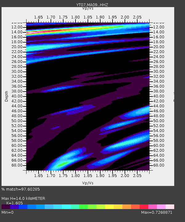
MA09 Polenet mini-array MA09 - Earthquake Result Viewer
| Earthquake location: |
New Britain Region, P.N.G. |
| Earthquake latitude/longitude: |
-4.7/152.6 |
| Earthquake time(UTC): |
2015/03/29 (088) 23:48:34 GMT |
| Earthquake Depth: |
66 km |
| Earthquake Magnitude: |
7.7 MWP, 7.6 MI |
| Earthquake Catalog/Contributor: |
NEIC PDE/NEIC COMCAT |
|
| Network: |
YT POLENET |
| Station: |
MA09 Polenet mini-array MA09 |
| Lat/Lon: |
79.90 S/105.00 W |
| Elevation: |
2009 m |
|
| Distance: |
87.5 deg |
| Az: |
170.065 deg |
| Baz: |
256.934 deg |
| Ray Param: |
0.043132853 |
| Estimated Moho Depth: |
14.0 km |
| Estimated Crust Vp/Vs: |
1.61 |
| Assumed Crust Vp: |
5.77 km/s |
| Estimated Crust Vs: |
3.595 km/s |
| Estimated Crust Poisson's Ratio: |
0.18 |
|
| Radial Match: |
97.60285 % |
| Radial Bump: |
362 |
| Transverse Match: |
92.19978 % |
| Transverse Bump: |
400 |
| SOD ConfigId: |
7422571 |
| Insert Time: |
2019-04-17 23:19:35.121 +0000 |
| GWidth: |
2.5 |
| Max Bumps: |
400 |
| Tol: |
0.001 |
|

Signal To Noise
| Channel | StoN | STA | LTA |
| YT:MA09: :HHZ:20150330T00:00:43.158987Z | 4.190927 | 9.543284E-7 | 2.2771295E-7 |
| YT:MA09: :HHN:20150330T00:00:43.158987Z | 2.0664735 | 3.2655316E-7 | 1.5802435E-7 |
| YT:MA09: :HHE:20150330T00:00:43.158987Z | 1.7706872 | 2.9025023E-7 | 1.6391954E-7 |
| Arrivals |
| Ps | 1.5 SECOND |
| PpPs | 6.2 SECOND |
| PsPs/PpSs | 7.7 SECOND |


