You are here: Home > Network List > NI - North-East Italy Broadband Network Stations List
> Station CGRP Cima Grappa > Earthquake Result Viewer
CGRP Cima Grappa - Earthquake Result Viewer
| Earthquake location: |
Near Coast Of Chiapas, Mexico |
| Earthquake latitude/longitude: |
14.7/-92.4 |
| Earthquake time(UTC): |
2014/07/07 (188) 11:23:55 GMT |
| Earthquake Depth: |
60 km |
| Earthquake Magnitude: |
6.9 MWW, 6.9 MWC, 7.1 MI |
| Earthquake Catalog/Contributor: |
NEIC PDE/NEIC COMCAT |
|
| Network: |
NI North-East Italy Broadband Network |
| Station: |
CGRP Cima Grappa |
| Lat/Lon: |
45.88 N/11.80 E |
| Elevation: |
1757 m |
|
| Distance: |
89.1 deg |
| Az: |
42.629 deg |
| Baz: |
290.284 deg |
| Ray Param: |
0.04196224 |
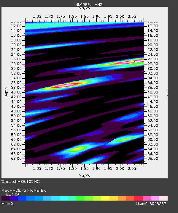
| Estimated Moho Depth: |
26.75 km |
| Estimated Crust Vp/Vs: |
2.06 |
| Assumed Crust Vp: |
6.155 km/s |
| Estimated Crust Vs: |
2.988 km/s |
| Estimated Crust Poisson's Ratio: |
0.35 |
|
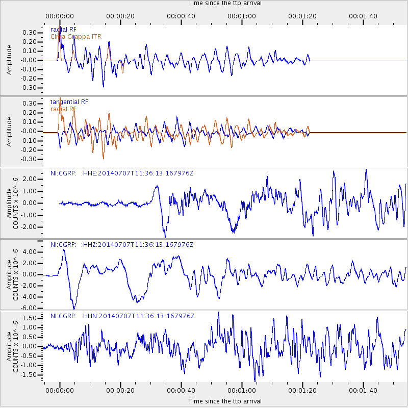
| Radial Match: |
88.102905 % |
| Radial Bump: |
400 |
| Transverse Match: |
79.923775 % |
| Transverse Bump: |
400 |
| SOD ConfigId: |
751272 |
| Insert Time: |
2014-07-21 12:03:15.478 +0000 |
| GWidth: |
2.5 |
| Max Bumps: |
400 |
| Tol: |
0.001 |
|
Signal To Noise
| Channel | StoN | STA | LTA |
| NI:CGRP: :HHZ:20140707T11:36:13.167976Z | 62.52076 | 3.1302632E-6 | 5.0067584E-8 |
| NI:CGRP: :HHN:20140707T11:36:13.167976Z | 1.6297259 | 1.2880459E-7 | 7.90345E-8 |
| NI:CGRP: :HHE:20140707T11:36:13.167976Z | 12.897531 | 1.180462E-6 | 9.152621E-8 |
| Arrivals |
| Ps | 4.7 SECOND |
| PpPs | 13 SECOND |
| PsPs/PpSs | 18 SECOND |


