You are here: Home > Network List > ZJ12 - Transantarctic Mountains Northern Network Stations List
> Station SAMH East Antarctica > Earthquake Result Viewer
SAMH East Antarctica - Earthquake Result Viewer
| Earthquake location: |
New Britain Region, P.N.G. |
| Earthquake latitude/longitude: |
-4.7/152.6 |
| Earthquake time(UTC): |
2015/03/29 (088) 23:48:34 GMT |
| Earthquake Depth: |
66 km |
| Earthquake Magnitude: |
7.7 MWP, 7.6 MI |
| Earthquake Catalog/Contributor: |
NEIC PDE/NEIC COMCAT |
|
| Network: |
ZJ Transantarctic Mountains Northern Network |
| Station: |
SAMH East Antarctica |
| Lat/Lon: |
75.20 S/154.00 E |
| Elevation: |
2087 m |
|
| Distance: |
70.4 deg |
| Az: |
179.608 deg |
| Baz: |
358.48 deg |
| Ray Param: |
0.054862954 |
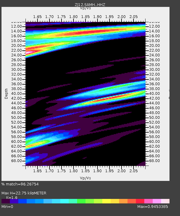
| Estimated Moho Depth: |
22.75 km |
| Estimated Crust Vp/Vs: |
1.60 |
| Assumed Crust Vp: |
6.262 km/s |
| Estimated Crust Vs: |
3.914 km/s |
| Estimated Crust Poisson's Ratio: |
0.18 |
|
| Radial Match: |
96.26754 % |
| Radial Bump: |
400 |
| Transverse Match: |
90.58412 % |
| Transverse Bump: |
400 |
| SOD ConfigId: |
7422571 |
| Insert Time: |
2019-04-17 23:19:54.718 +0000 |
| GWidth: |
2.5 |
| Max Bumps: |
400 |
| Tol: |
0.001 |
|

Signal To Noise
| Channel | StoN | STA | LTA |
| ZJ:SAMH: :HHZ:20150329T23:59:09.718984Z | 4.519171 | 1.3234527E-6 | 2.9285297E-7 |
| ZJ:SAMH: :HHN:20150329T23:59:09.718984Z | 1.7114081 | 9.767259E-7 | 5.7071475E-7 |
| ZJ:SAMH: :HHE:20150329T23:59:09.718984Z | 1.7232668 | 4.99353E-7 | 2.8977115E-7 |
| Arrivals |
| Ps | 2.3 SECOND |
| PpPs | 9.1 SECOND |
| PsPs/PpSs | 11 SECOND |


