You are here: Home > Network List > PL - Polish Seismological Network Stations List
> Station GKP GORKA KLASZTORNA, POLAND > Earthquake Result Viewer
GKP GORKA KLASZTORNA, POLAND - Earthquake Result Viewer
| Earthquake location: |
Near Coast Of Chiapas, Mexico |
| Earthquake latitude/longitude: |
14.7/-92.4 |
| Earthquake time(UTC): |
2014/07/07 (188) 11:23:55 GMT |
| Earthquake Depth: |
60 km |
| Earthquake Magnitude: |
6.9 MWW, 6.9 MWC, 7.1 MI |
| Earthquake Catalog/Contributor: |
NEIC PDE/NEIC COMCAT |
|
| Network: |
PL Polish Seismological Network |
| Station: |
GKP GORKA KLASZTORNA, POLAND |
| Lat/Lon: |
53.27 N/17.24 E |
| Elevation: |
115 m |
|
| Distance: |
89.6 deg |
| Az: |
34.449 deg |
| Baz: |
294.328 deg |
| Ray Param: |
0.041722283 |
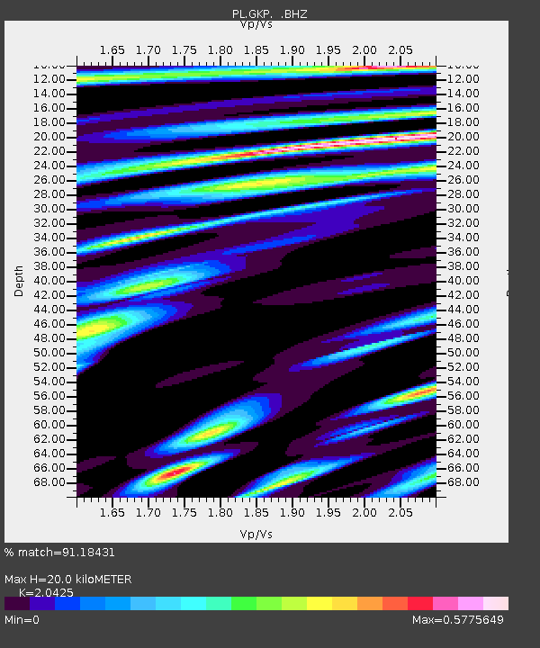
| Estimated Moho Depth: |
20.0 km |
| Estimated Crust Vp/Vs: |
2.04 |
| Assumed Crust Vp: |
6.234 km/s |
| Estimated Crust Vs: |
3.052 km/s |
| Estimated Crust Poisson's Ratio: |
0.34 |
|
| Radial Match: |
91.18431 % |
| Radial Bump: |
400 |
| Transverse Match: |
85.62158 % |
| Transverse Bump: |
400 |
| SOD ConfigId: |
751272 |
| Insert Time: |
2014-07-21 12:04:51.557 +0000 |
| GWidth: |
2.5 |
| Max Bumps: |
400 |
| Tol: |
0.001 |
|

Signal To Noise
| Channel | StoN | STA | LTA |
| PL:GKP: :BHZ:20140707T11:36:15.351021Z | 13.792269 | 3.040127E-6 | 2.2042255E-7 |
| PL:GKP: :BHN:20140707T11:36:15.351021Z | 1.3491646 | 2.8275207E-7 | 2.0957567E-7 |
| PL:GKP: :BHE:20140707T11:36:15.351021Z | 3.3500915 | 7.126511E-7 | 2.1272587E-7 |
| Arrivals |
| Ps | 3.4 SECOND |
| PpPs | 9.6 SECOND |
| PsPs/PpSs | 13 SECOND |


