You are here: Home > Network List > TA - USArray Transportable Network (new EarthScope stations) Stations List
> Station D04E Lakebay, WA, USA > Earthquake Result Viewer
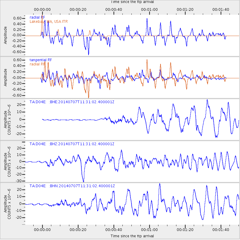
D04E Lakebay, WA, USA - Earthquake Result Viewer
*The percent match for this event was below the threshold and hence no stack was calculated.
| Earthquake location: |
Near Coast Of Chiapas, Mexico |
| Earthquake latitude/longitude: |
14.7/-92.4 |
| Earthquake time(UTC): |
2014/07/07 (188) 11:23:55 GMT |
| Earthquake Depth: |
60 km |
| Earthquake Magnitude: |
6.9 MWW, 6.9 MWC, 7.1 MI |
| Earthquake Catalog/Contributor: |
NEIC PDE/NEIC COMCAT |
|
| Network: |
TA USArray Transportable Network (new EarthScope stations) |
| Station: |
D04E Lakebay, WA, USA |
| Lat/Lon: |
47.18 N/122.77 W |
| Elevation: |
45 m |
|
| Distance: |
41.0 deg |
| Az: |
328.313 deg |
| Baz: |
131.842 deg |
| Ray Param: |
$rayparam |
*The percent match for this event was below the threshold and hence was not used in the summary stack. |
|
| Radial Match: |
86.4599 % |
| Radial Bump: |
371 |
| Transverse Match: |
68.671486 % |
| Transverse Bump: |
400 |
| SOD ConfigId: |
751272 |
| Insert Time: |
2014-07-21 12:07:48.587 +0000 |
| GWidth: |
2.5 |
| Max Bumps: |
400 |
| Tol: |
0.001 |
|
Signal To Noise
| Channel | StoN | STA | LTA |
| TA:D04E: :BHZ:20140707T11:31:02.400001Z | 5.9355927 | 3.081208E-6 | 5.1910706E-7 |
| TA:D04E: :BHN:20140707T11:31:02.400001Z | 2.6749687 | 1.0642101E-6 | 3.9784018E-7 |
| TA:D04E: :BHE:20140707T11:31:02.400001Z | 2.803074 | 9.652903E-7 | 3.4436846E-7 |
| Arrivals |
| Ps | |
| PpPs | |
| PsPs/PpSs | |


