You are here: Home > Network List > AK - Alaska Regional Network Stations List
> Station KNK Knik Glacier, AK, USA > Earthquake Result Viewer
KNK Knik Glacier, AK, USA - Earthquake Result Viewer
| Earthquake location: |
New Britain Region, P.N.G. |
| Earthquake latitude/longitude: |
-5.2/152.6 |
| Earthquake time(UTC): |
2015/03/30 (089) 00:15:30 GMT |
| Earthquake Depth: |
35 km |
| Earthquake Magnitude: |
5.7 MB |
| Earthquake Catalog/Contributor: |
NEIC PDE/NEIC COMCAT |
|
| Network: |
AK Alaska Regional Network |
| Station: |
KNK Knik Glacier, AK, USA |
| Lat/Lon: |
61.41 N/148.46 W |
| Elevation: |
598 m |
|
| Distance: |
80.3 deg |
| Az: |
24.706 deg |
| Baz: |
239.941 deg |
| Ray Param: |
0.04832672 |
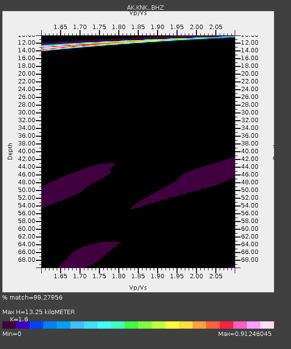
| Estimated Moho Depth: |
13.25 km |
| Estimated Crust Vp/Vs: |
1.60 |
| Assumed Crust Vp: |
6.566 km/s |
| Estimated Crust Vs: |
4.104 km/s |
| Estimated Crust Poisson's Ratio: |
0.18 |
|
| Radial Match: |
99.27956 % |
| Radial Bump: |
207 |
| Transverse Match: |
94.32296 % |
| Transverse Bump: |
108 |
| SOD ConfigId: |
7422571 |
| Insert Time: |
2019-04-17 23:20:20.475 +0000 |
| GWidth: |
2.5 |
| Max Bumps: |
400 |
| Tol: |
0.001 |
|

Signal To Noise
| Channel | StoN | STA | LTA |
| AK:KNK: :BHZ:20150330T00:27:06.587993Z | 2.1701095 | 1.1109183E-4 | 5.119181E-5 |
| AK:KNK: :BHN:20150330T00:27:06.587993Z | 1.4294866 | 2.1544512E-5 | 1.5071504E-5 |
| AK:KNK: :BHE:20150330T00:27:06.587993Z | 0.85009205 | 2.8052531E-5 | 3.2999404E-5 |
| Arrivals |
| Ps | 1.3 SECOND |
| PpPs | 5.1 SECOND |
| PsPs/PpSs | 6.3 SECOND |


