You are here: Home > Network List > AK - Alaska Regional Network Stations List
> Station PNL Peninsula > Earthquake Result Viewer
PNL Peninsula - Earthquake Result Viewer
| Earthquake location: |
New Britain Region, P.N.G. |
| Earthquake latitude/longitude: |
-5.2/152.6 |
| Earthquake time(UTC): |
2015/03/30 (089) 00:15:30 GMT |
| Earthquake Depth: |
35 km |
| Earthquake Magnitude: |
5.7 MB |
| Earthquake Catalog/Contributor: |
NEIC PDE/NEIC COMCAT |
|
| Network: |
AK Alaska Regional Network |
| Station: |
PNL Peninsula |
| Lat/Lon: |
59.67 N/139.40 W |
| Elevation: |
596 m |
|
| Distance: |
83.6 deg |
| Az: |
28.265 deg |
| Baz: |
248.321 deg |
| Ray Param: |
0.04605442 |
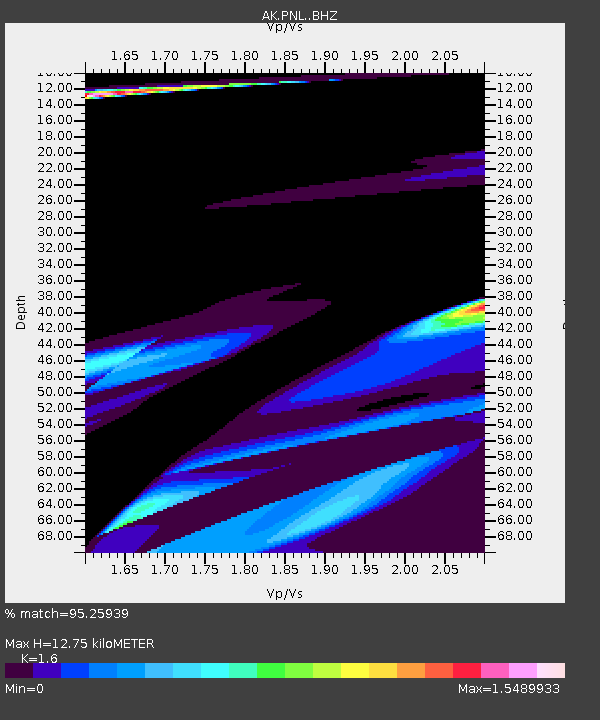
| Estimated Moho Depth: |
12.75 km |
| Estimated Crust Vp/Vs: |
1.60 |
| Assumed Crust Vp: |
6.183 km/s |
| Estimated Crust Vs: |
3.864 km/s |
| Estimated Crust Poisson's Ratio: |
0.18 |
|
| Radial Match: |
95.25939 % |
| Radial Bump: |
400 |
| Transverse Match: |
70.03578 % |
| Transverse Bump: |
400 |
| SOD ConfigId: |
7422571 |
| Insert Time: |
2019-04-17 23:20:27.697 +0000 |
| GWidth: |
2.5 |
| Max Bumps: |
400 |
| Tol: |
0.001 |
|

Signal To Noise
| Channel | StoN | STA | LTA |
| AK:PNL: :BHZ:20150330T00:27:23.627971Z | 0.7021261 | 1.3415001E-5 | 1.9106257E-5 |
| AK:PNL: :BHN:20150330T00:27:23.627971Z | 2.5295737 | 2.8597386E-5 | 1.1305219E-5 |
| AK:PNL: :BHE:20150330T00:27:23.627971Z | 1.7533116 | 3.562904E-5 | 2.0320995E-5 |
| Arrivals |
| Ps | 1.3 SECOND |
| PpPs | 5.2 SECOND |
| PsPs/PpSs | 6.5 SECOND |


