You are here: Home > Network List > TA - USArray Transportable Network (new EarthScope stations) Stations List
> Station E50A Wahnapitae, ON, CAN > Earthquake Result Viewer
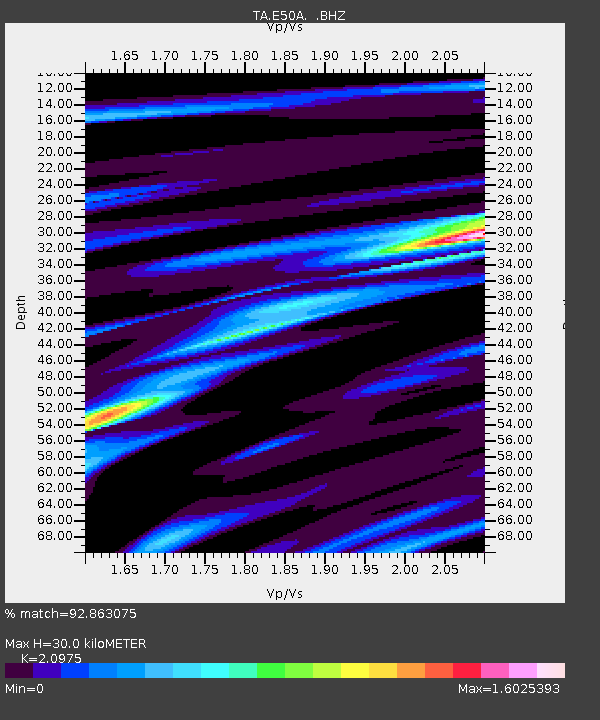
E50A Wahnapitae, ON, CAN - Earthquake Result Viewer
| Earthquake location: |
Near Coast Of Chiapas, Mexico |
| Earthquake latitude/longitude: |
14.7/-92.4 |
| Earthquake time(UTC): |
2014/07/07 (188) 11:23:55 GMT |
| Earthquake Depth: |
60 km |
| Earthquake Magnitude: |
6.9 MWW, 6.9 MWC, 7.1 MI |
| Earthquake Catalog/Contributor: |
NEIC PDE/NEIC COMCAT |
|
| Network: |
TA USArray Transportable Network (new EarthScope stations) |
| Station: |
E50A Wahnapitae, ON, CAN |
| Lat/Lon: |
46.42 N/80.74 W |
| Elevation: |
242 m |
|
| Distance: |
33.1 deg |
| Az: |
14.861 deg |
| Baz: |
201.021 deg |
| Ray Param: |
0.078234956 |
| Estimated Moho Depth: |
30.0 km |
| Estimated Crust Vp/Vs: |
2.10 |
| Assumed Crust Vp: |
6.467 km/s |
| Estimated Crust Vs: |
3.083 km/s |
| Estimated Crust Poisson's Ratio: |
0.35 |
|
| Radial Match: |
92.863075 % |
| Radial Bump: |
286 |
| Transverse Match: |
79.29561 % |
| Transverse Bump: |
400 |
| SOD ConfigId: |
751272 |
| Insert Time: |
2014-07-21 12:08:58.622 +0000 |
| GWidth: |
2.5 |
| Max Bumps: |
400 |
| Tol: |
0.001 |
|

Signal To Noise
| Channel | StoN | STA | LTA |
| TA:E50A: :BHZ:20140707T11:29:55.074989Z | 35.308765 | 5.4802495E-6 | 1.5520932E-7 |
| TA:E50A: :BHN:20140707T11:29:55.074989Z | 34.068302 | 4.119635E-6 | 1.2092282E-7 |
| TA:E50A: :BHE:20140707T11:29:55.074989Z | 19.817022 | 1.4357064E-6 | 7.244814E-8 |
| Arrivals |
| Ps | 5.4 SECOND |
| PpPs | 13 SECOND |
| PsPs/PpSs | 19 SECOND |


