You are here: Home > Network List > TA - USArray Transportable Network (new EarthScope stations) Stations List
> Station E56A St. Veronique, QC, CAN > Earthquake Result Viewer
E56A St. Veronique, QC, CAN - Earthquake Result Viewer
| Earthquake location: |
Near Coast Of Chiapas, Mexico |
| Earthquake latitude/longitude: |
14.7/-92.4 |
| Earthquake time(UTC): |
2014/07/07 (188) 11:23:55 GMT |
| Earthquake Depth: |
60 km |
| Earthquake Magnitude: |
6.9 MWW, 6.9 MWC, 7.1 MI |
| Earthquake Catalog/Contributor: |
NEIC PDE/NEIC COMCAT |
|
| Network: |
TA USArray Transportable Network (new EarthScope stations) |
| Station: |
E56A St. Veronique, QC, CAN |
| Lat/Lon: |
46.54 N/75.03 W |
| Elevation: |
320 m |
|
| Distance: |
34.9 deg |
| Az: |
21.124 deg |
| Baz: |
210.342 deg |
| Ray Param: |
0.07735202 |
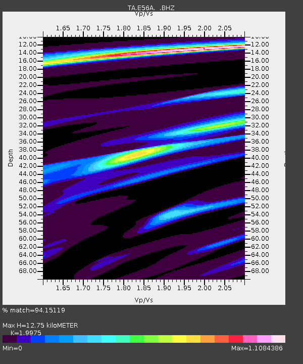
| Estimated Moho Depth: |
12.75 km |
| Estimated Crust Vp/Vs: |
2.00 |
| Assumed Crust Vp: |
6.61 km/s |
| Estimated Crust Vs: |
3.309 km/s |
| Estimated Crust Poisson's Ratio: |
0.33 |
|
| Radial Match: |
94.15119 % |
| Radial Bump: |
270 |
| Transverse Match: |
77.82661 % |
| Transverse Bump: |
400 |
| SOD ConfigId: |
751272 |
| Insert Time: |
2014-07-21 12:09:14.710 +0000 |
| GWidth: |
2.5 |
| Max Bumps: |
400 |
| Tol: |
0.001 |
|

Signal To Noise
| Channel | StoN | STA | LTA |
| TA:E56A: :BHZ:20140707T11:30:10.775001Z | 72.35868 | 9.827548E-6 | 1.3581713E-7 |
| TA:E56A: :BHN:20140707T11:30:10.775001Z | 21.37766 | 4.766292E-6 | 2.2295666E-7 |
| TA:E56A: :BHE:20140707T11:30:10.775001Z | 24.830442 | 2.899267E-6 | 1.167626E-7 |
| Arrivals |
| Ps | 2.1 SECOND |
| PpPs | 5.4 SECOND |
| PsPs/PpSs | 7.4 SECOND |


