You are here: Home > Network List > TA - USArray Transportable Network (new EarthScope stations) Stations List
> Station E60A Ste Agathe de Lotbiniere, QC, CAN > Earthquake Result Viewer
E60A Ste Agathe de Lotbiniere, QC, CAN - Earthquake Result Viewer

| Earthquake location: |
Near Coast Of Chiapas, Mexico |
| Earthquake latitude/longitude: |
14.7/-92.4 |
| Earthquake time(UTC): |
2014/07/07 (188) 11:23:55 GMT |
| Earthquake Depth: |
60 km |
| Earthquake Magnitude: |
6.9 MWW, 6.9 MWC, 7.1 MI |
| Earthquake Catalog/Contributor: |
NEIC PDE/NEIC COMCAT |
|
| Network: |
TA USArray Transportable Network (new EarthScope stations) |
| Station: |
E60A Ste Agathe de Lotbiniere, QC, CAN |
| Lat/Lon: |
46.37 N/71.45 W |
| Elevation: |
181 m |
|
| Distance: |
36.1 deg |
| Az: |
24.865 deg |
| Baz: |
215.98 deg |
| Ray Param: |
0.076702125 |
| Estimated Moho Depth: |
59.75 km |
| Estimated Crust Vp/Vs: |
2.10 |
| Assumed Crust Vp: |
6.61 km/s |
| Estimated Crust Vs: |
3.151 km/s |
| Estimated Crust Poisson's Ratio: |
0.35 |
|
| Radial Match: |
91.495224 % |
| Radial Bump: |
311 |
| Transverse Match: |
80.72201 % |
| Transverse Bump: |
400 |
| SOD ConfigId: |
751272 |
| Insert Time: |
2014-07-21 12:09:28.369 +0000 |
| GWidth: |
2.5 |
| Max Bumps: |
400 |
| Tol: |
0.001 |
|
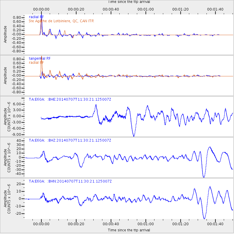
Signal To Noise
| Channel | StoN | STA | LTA |
| TA:E60A: :BHZ:20140707T11:30:21.125007Z | 45.699158 | 8.472379E-6 | 1.8539464E-7 |
| TA:E60A: :BHN:20140707T11:30:21.125007Z | 6.0034757 | 3.737863E-6 | 6.226165E-7 |
| TA:E60A: :BHE:20140707T11:30:21.125007Z | 7.155316 | 3.0924687E-6 | 4.3219174E-7 |
| Arrivals |
| Ps | 11 SECOND |
| PpPs | 26 SECOND |
| PsPs/PpSs | 37 SECOND |


