You are here: Home > Network List > TA - USArray Transportable Network (new EarthScope stations) Stations List
> Station F05D White Salmon, WA, USA > Earthquake Result Viewer
F05D White Salmon, WA, USA - Earthquake Result Viewer
| Earthquake location: |
Near Coast Of Chiapas, Mexico |
| Earthquake latitude/longitude: |
14.7/-92.4 |
| Earthquake time(UTC): |
2014/07/07 (188) 11:23:55 GMT |
| Earthquake Depth: |
60 km |
| Earthquake Magnitude: |
6.9 MWW, 6.9 MWC, 7.1 MI |
| Earthquake Catalog/Contributor: |
NEIC PDE/NEIC COMCAT |
|
| Network: |
TA USArray Transportable Network (new EarthScope stations) |
| Station: |
F05D White Salmon, WA, USA |
| Lat/Lon: |
45.89 N/121.46 W |
| Elevation: |
472 m |
|
| Distance: |
39.5 deg |
| Az: |
327.768 deg |
| Baz: |
132.375 deg |
| Ray Param: |
0.074784376 |
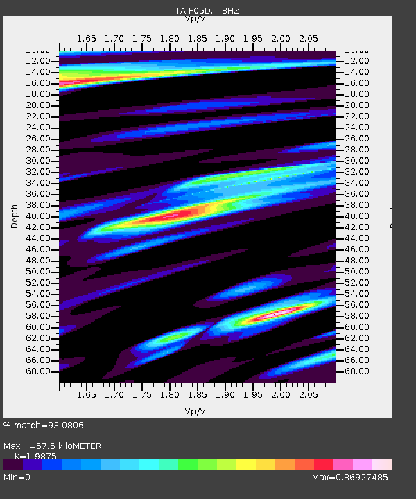
| Estimated Moho Depth: |
57.5 km |
| Estimated Crust Vp/Vs: |
1.99 |
| Assumed Crust Vp: |
6.597 km/s |
| Estimated Crust Vs: |
3.319 km/s |
| Estimated Crust Poisson's Ratio: |
0.33 |
|
| Radial Match: |
93.0806 % |
| Radial Bump: |
400 |
| Transverse Match: |
86.22639 % |
| Transverse Bump: |
392 |
| SOD ConfigId: |
751272 |
| Insert Time: |
2014-07-21 12:09:53.218 +0000 |
| GWidth: |
2.5 |
| Max Bumps: |
400 |
| Tol: |
0.001 |
|

Signal To Noise
| Channel | StoN | STA | LTA |
| TA:F05D: :BHZ:20140707T11:30:49.699989Z | 54.091854 | 3.9906076E-6 | 7.377465E-8 |
| TA:F05D: :BHN:20140707T11:30:49.699989Z | 13.196026 | 1.5396222E-6 | 1.1667317E-7 |
| TA:F05D: :BHE:20140707T11:30:49.699989Z | 13.145061 | 1.3681897E-6 | 1.04083945E-7 |
| Arrivals |
| Ps | 9.2 SECOND |
| PpPs | 24 SECOND |
| PsPs/PpSs | 34 SECOND |


