You are here: Home > Network List > AV - Alaska Volcano Observatory Stations List
> Station SPCP Crater Peak Broadband, Mount Spurr, Alaska > Earthquake Result Viewer
SPCP Crater Peak Broadband, Mount Spurr, Alaska - Earthquake Result Viewer
| Earthquake location: |
New Britain Region, P.N.G. |
| Earthquake latitude/longitude: |
-5.2/152.6 |
| Earthquake time(UTC): |
2015/03/30 (089) 00:15:30 GMT |
| Earthquake Depth: |
35 km |
| Earthquake Magnitude: |
5.7 MB |
| Earthquake Catalog/Contributor: |
NEIC PDE/NEIC COMCAT |
|
| Network: |
AV Alaska Volcano Observatory |
| Station: |
SPCP Crater Peak Broadband, Mount Spurr, Alaska |
| Lat/Lon: |
61.27 N/152.15 W |
| Elevation: |
1616 m |
|
| Distance: |
78.7 deg |
| Az: |
23.881 deg |
| Baz: |
236.552 deg |
| Ray Param: |
0.04941418 |
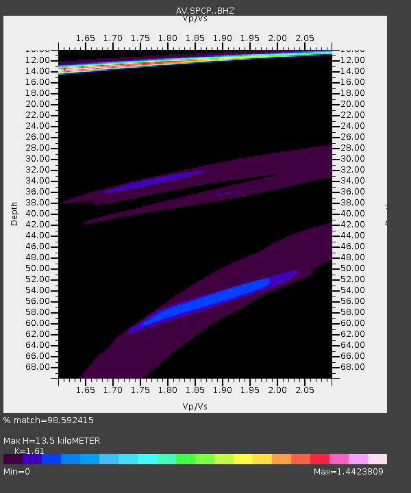
| Estimated Moho Depth: |
13.5 km |
| Estimated Crust Vp/Vs: |
1.61 |
| Assumed Crust Vp: |
6.566 km/s |
| Estimated Crust Vs: |
4.078 km/s |
| Estimated Crust Poisson's Ratio: |
0.19 |
|
| Radial Match: |
98.592415 % |
| Radial Bump: |
400 |
| Transverse Match: |
95.42736 % |
| Transverse Bump: |
319 |
| SOD ConfigId: |
7422571 |
| Insert Time: |
2019-04-17 23:21:00.278 +0000 |
| GWidth: |
2.5 |
| Max Bumps: |
400 |
| Tol: |
0.001 |
|

Signal To Noise
| Channel | StoN | STA | LTA |
| AV:SPCP: :BHZ:20150330T00:26:57.960002Z | 1.8472196 | 8.252592E-5 | 4.467575E-5 |
| AV:SPCP: :BHN:20150330T00:26:57.960002Z | 0.7751228 | 2.3811164E-5 | 3.0719213E-5 |
| AV:SPCP: :BHE:20150330T00:26:57.960002Z | 1.4229745 | 1.9823165E-5 | 1.3930794E-5 |
| Arrivals |
| Ps | 1.3 SECOND |
| PpPs | 5.2 SECOND |
| PsPs/PpSs | 6.5 SECOND |


