You are here: Home > Network List > TA - USArray Transportable Network (new EarthScope stations) Stations List
> Station F48A Evansville, ON, CAN > Earthquake Result Viewer
F48A Evansville, ON, CAN - Earthquake Result Viewer
| Earthquake location: |
Near Coast Of Chiapas, Mexico |
| Earthquake latitude/longitude: |
14.7/-92.4 |
| Earthquake time(UTC): |
2014/07/07 (188) 11:23:55 GMT |
| Earthquake Depth: |
60 km |
| Earthquake Magnitude: |
6.9 MWW, 6.9 MWC, 7.1 MI |
| Earthquake Catalog/Contributor: |
NEIC PDE/NEIC COMCAT |
|
| Network: |
TA USArray Transportable Network (new EarthScope stations) |
| Station: |
F48A Evansville, ON, CAN |
| Lat/Lon: |
45.83 N/82.62 W |
| Elevation: |
203 m |
|
| Distance: |
32.1 deg |
| Az: |
12.941 deg |
| Baz: |
198.052 deg |
| Ray Param: |
0.07867535 |
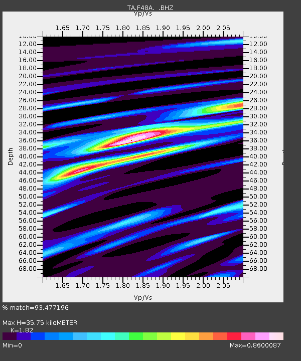
| Estimated Moho Depth: |
35.75 km |
| Estimated Crust Vp/Vs: |
1.82 |
| Assumed Crust Vp: |
6.483 km/s |
| Estimated Crust Vs: |
3.562 km/s |
| Estimated Crust Poisson's Ratio: |
0.28 |
|
| Radial Match: |
93.477196 % |
| Radial Bump: |
239 |
| Transverse Match: |
68.629845 % |
| Transverse Bump: |
400 |
| SOD ConfigId: |
751272 |
| Insert Time: |
2014-07-21 12:09:59.737 +0000 |
| GWidth: |
2.5 |
| Max Bumps: |
400 |
| Tol: |
0.001 |
|
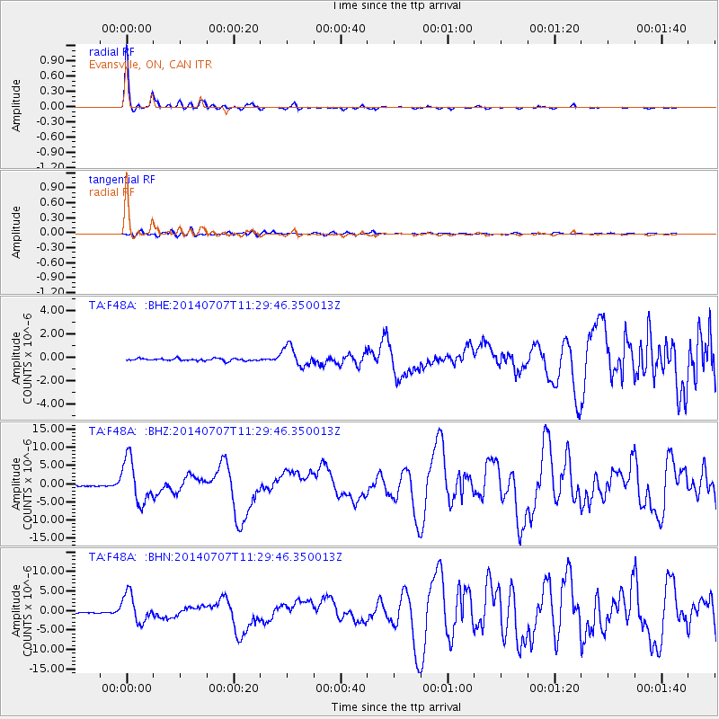
Signal To Noise
| Channel | StoN | STA | LTA |
| TA:F48A: :BHZ:20140707T11:29:46.350013Z | 36.22219 | 6.047597E-6 | 1.6695833E-7 |
| TA:F48A: :BHN:20140707T11:29:46.350013Z | 23.881767 | 3.696549E-6 | 1.547854E-7 |
| TA:F48A: :BHE:20140707T11:29:46.350013Z | 8.609492 | 8.560122E-7 | 9.942656E-8 |
| Arrivals |
| Ps | 4.9 SECOND |
| PpPs | 14 SECOND |
| PsPs/PpSs | 19 SECOND |


