You are here: Home > Network List > TA - USArray Transportable Network (new EarthScope stations) Stations List
> Station F58A St-Lin Laurentide, QC, CAN > Earthquake Result Viewer
F58A St-Lin Laurentide, QC, CAN - Earthquake Result Viewer
| Earthquake location: |
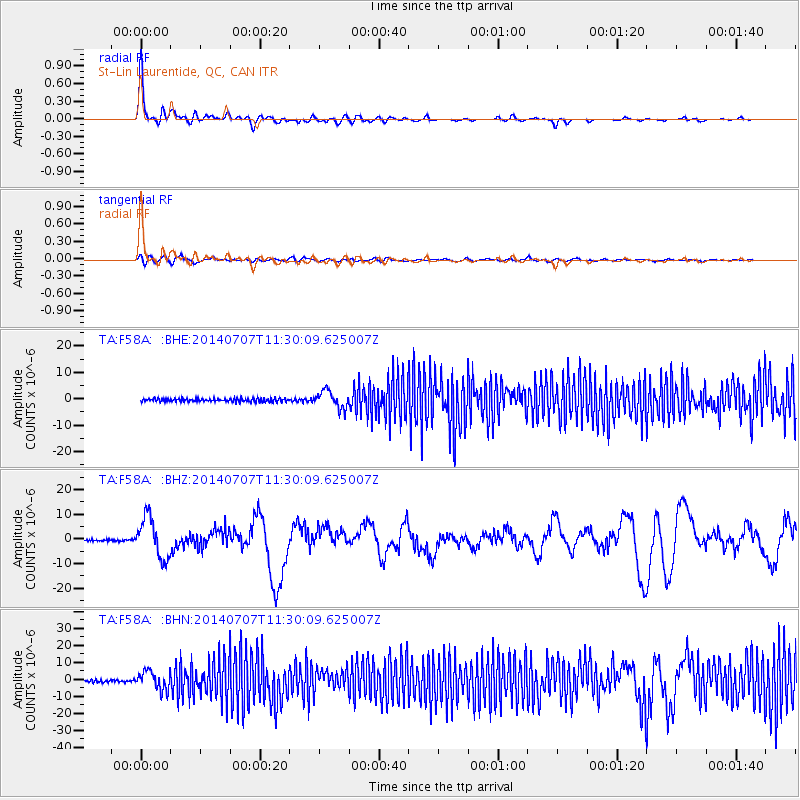
Near Coast Of Chiapas, Mexico |
| Earthquake latitude/longitude: |
14.7/-92.4 |
| Earthquake time(UTC): |
2014/07/07 (188) 11:23:55 GMT |
| Earthquake Depth: |
60 km |
| Earthquake Magnitude: |
6.9 MWW, 6.9 MWC, 7.1 MI |
| Earthquake Catalog/Contributor: |
NEIC PDE/NEIC COMCAT |
|
| Network: |
TA USArray Transportable Network (new EarthScope stations) |
| Station: |
F58A St-Lin Laurentide, QC, CAN |
| Lat/Lon: |
45.87 N/73.81 W |
| Elevation: |
73 m |
|
| Distance: |
34.8 deg |
| Az: |
23.009 deg |
| Baz: |
212.767 deg |
| Ray Param: |
0.07742111 |
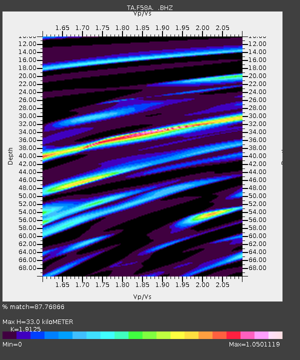
| Estimated Moho Depth: |
33.0 km |
| Estimated Crust Vp/Vs: |
1.91 |
| Assumed Crust Vp: |
6.419 km/s |
| Estimated Crust Vs: |
3.356 km/s |
| Estimated Crust Poisson's Ratio: |
0.31 |
|
| Radial Match: |
87.76866 % |
| Radial Bump: |
400 |
| Transverse Match: |
56.887257 % |
| Transverse Bump: |
400 |
| SOD ConfigId: |
751272 |
| Insert Time: |
2014-07-21 12:10:20.783 +0000 |
| GWidth: |
2.5 |
| Max Bumps: |
400 |
| Tol: |
0.001 |
|
Signal To Noise
| Channel | StoN | STA | LTA |
| TA:F58A: :BHZ:20140707T11:30:09.625007Z | 24.301579 | 8.165425E-6 | 3.3600392E-7 |
| TA:F58A: :BHN:20140707T11:30:09.625007Z | 9.220803 | 5.504287E-6 | 5.969422E-7 |
| TA:F58A: :BHE:20140707T11:30:09.625007Z | 5.3562646 | 3.2898736E-6 | 6.142104E-7 |
| Arrivals |
| Ps | 5.0 SECOND |
| PpPs | 14 SECOND |
| PsPs/PpSs | 19 SECOND |


