You are here: Home > Network List > TA - USArray Transportable Network (new EarthScope stations) Stations List
> Station F63A Nahmakanta, Browneville, ME, USA > Earthquake Result Viewer
F63A Nahmakanta, Browneville, ME, USA - Earthquake Result Viewer
| Earthquake location: |
Near Coast Of Chiapas, Mexico |
| Earthquake latitude/longitude: |
14.7/-92.4 |
| Earthquake time(UTC): |
2014/07/07 (188) 11:23:55 GMT |
| Earthquake Depth: |
60 km |
| Earthquake Magnitude: |
6.9 MWW, 6.9 MWC, 7.1 MI |
| Earthquake Catalog/Contributor: |
NEIC PDE/NEIC COMCAT |
|
| Network: |
TA USArray Transportable Network (new EarthScope stations) |
| Station: |
F63A Nahmakanta, Browneville, ME, USA |
| Lat/Lon: |
45.70 N/69.10 W |
| Elevation: |
386 m |
|
| Distance: |
36.6 deg |
| Az: |
27.729 deg |
| Baz: |
219.97 deg |
| Ray Param: |
0.076441534 |
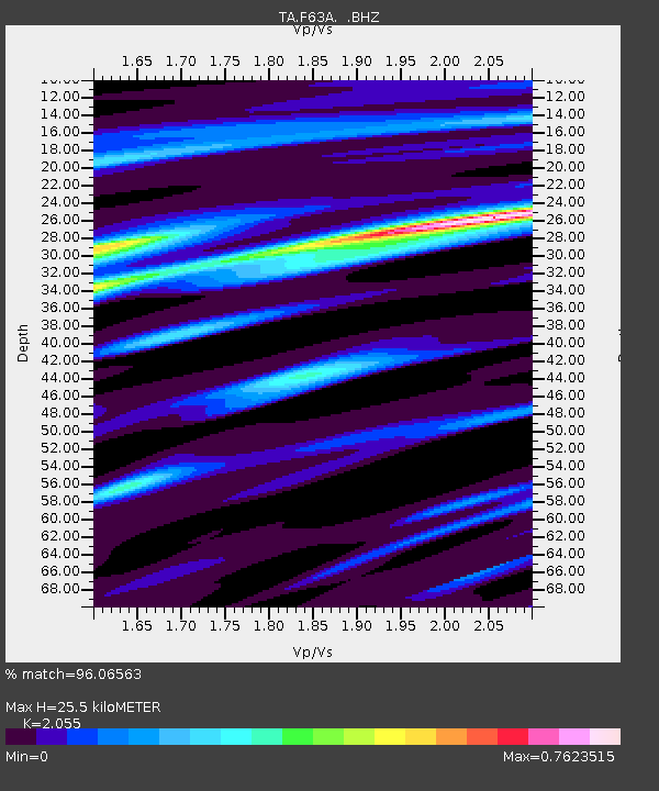
| Estimated Moho Depth: |
25.5 km |
| Estimated Crust Vp/Vs: |
2.06 |
| Assumed Crust Vp: |
6.419 km/s |
| Estimated Crust Vs: |
3.124 km/s |
| Estimated Crust Poisson's Ratio: |
0.34 |
|
| Radial Match: |
96.06563 % |
| Radial Bump: |
279 |
| Transverse Match: |
74.206314 % |
| Transverse Bump: |
400 |
| SOD ConfigId: |
751272 |
| Insert Time: |
2014-07-21 12:10:35.589 +0000 |
| GWidth: |
2.5 |
| Max Bumps: |
400 |
| Tol: |
0.001 |
|

Signal To Noise
| Channel | StoN | STA | LTA |
| TA:F63A: :BHZ:20140707T11:30:25.225013Z | 25.10566 | 6.133648E-6 | 2.4431338E-7 |
| TA:F63A: :BHN:20140707T11:30:25.225013Z | 16.994793 | 2.9892433E-6 | 1.7589173E-7 |
| TA:F63A: :BHE:20140707T11:30:25.225013Z | 16.172516 | 2.4209562E-6 | 1.4969571E-7 |
| Arrivals |
| Ps | 4.5 SECOND |
| PpPs | 11 SECOND |
| PsPs/PpSs | 16 SECOND |


