You are here: Home > Network List > TA - USArray Transportable Network (new EarthScope stations) Stations List
> Station G60A Masonville, QC, CAN > Earthquake Result Viewer
G60A Masonville, QC, CAN - Earthquake Result Viewer
| Earthquake location: |
Near Coast Of Chiapas, Mexico |
| Earthquake latitude/longitude: |
14.7/-92.4 |
| Earthquake time(UTC): |
2014/07/07 (188) 11:23:55 GMT |
| Earthquake Depth: |
60 km |
| Earthquake Magnitude: |
6.9 MWW, 6.9 MWC, 7.1 MI |
| Earthquake Catalog/Contributor: |
NEIC PDE/NEIC COMCAT |
|
| Network: |
TA USArray Transportable Network (new EarthScope stations) |
| Station: |
G60A Masonville, QC, CAN |
| Lat/Lon: |
45.10 N/72.33 W |
| Elevation: |
391 m |
|
| Distance: |
34.7 deg |
| Az: |
25.28 deg |
| Baz: |
215.686 deg |
| Ray Param: |
0.077446654 |
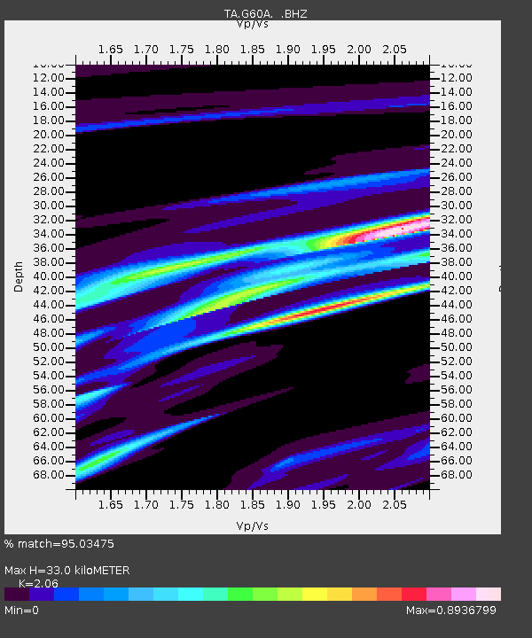
| Estimated Moho Depth: |
33.0 km |
| Estimated Crust Vp/Vs: |
2.06 |
| Assumed Crust Vp: |
6.419 km/s |
| Estimated Crust Vs: |
3.116 km/s |
| Estimated Crust Poisson's Ratio: |
0.35 |
|
| Radial Match: |
95.03475 % |
| Radial Bump: |
185 |
| Transverse Match: |
84.000145 % |
| Transverse Bump: |
400 |
| SOD ConfigId: |
751272 |
| Insert Time: |
2014-07-21 12:11:16.397 +0000 |
| GWidth: |
2.5 |
| Max Bumps: |
400 |
| Tol: |
0.001 |
|
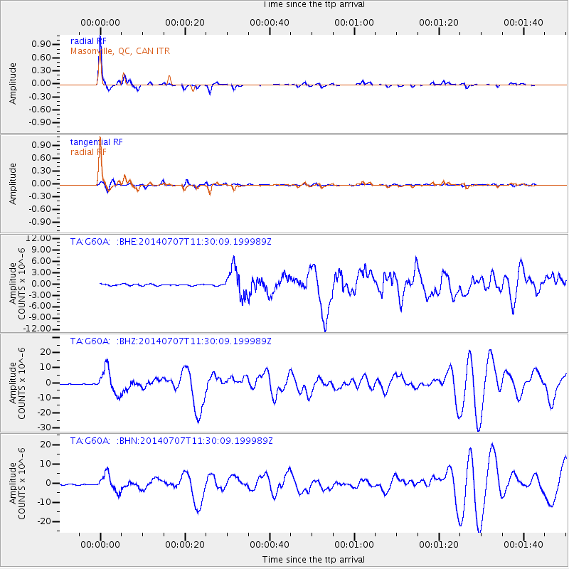
Signal To Noise
| Channel | StoN | STA | LTA |
| TA:G60A: :BHZ:20140707T11:30:09.199989Z | 43.187042 | 8.0756845E-6 | 1.8699322E-7 |
| TA:G60A: :BHN:20140707T11:30:09.199989Z | 24.342695 | 4.356279E-6 | 1.7895631E-7 |
| TA:G60A: :BHE:20140707T11:30:09.199989Z | 19.212154 | 3.5949724E-6 | 1.871197E-7 |
| Arrivals |
| Ps | 5.8 SECOND |
| PpPs | 15 SECOND |
| PsPs/PpSs | 21 SECOND |


