You are here: Home > Network List > TA - USArray Transportable Network (new EarthScope stations) Stations List
> Station H60A Morristown, VT, USA > Earthquake Result Viewer
H60A Morristown, VT, USA - Earthquake Result Viewer
| Earthquake location: |
Near Coast Of Chiapas, Mexico |
| Earthquake latitude/longitude: |
14.7/-92.4 |
| Earthquake time(UTC): |
2014/07/07 (188) 11:23:55 GMT |
| Earthquake Depth: |
60 km |
| Earthquake Magnitude: |
6.9 MWW, 6.9 MWC, 7.1 MI |
| Earthquake Catalog/Contributor: |
NEIC PDE/NEIC COMCAT |
|
| Network: |
TA USArray Transportable Network (new EarthScope stations) |
| Station: |
H60A Morristown, VT, USA |
| Lat/Lon: |
44.56 N/72.70 W |
| Elevation: |
459 m |
|
| Distance: |
34.1 deg |
| Az: |
25.461 deg |
| Baz: |
215.579 deg |
| Ray Param: |
0.07774961 |
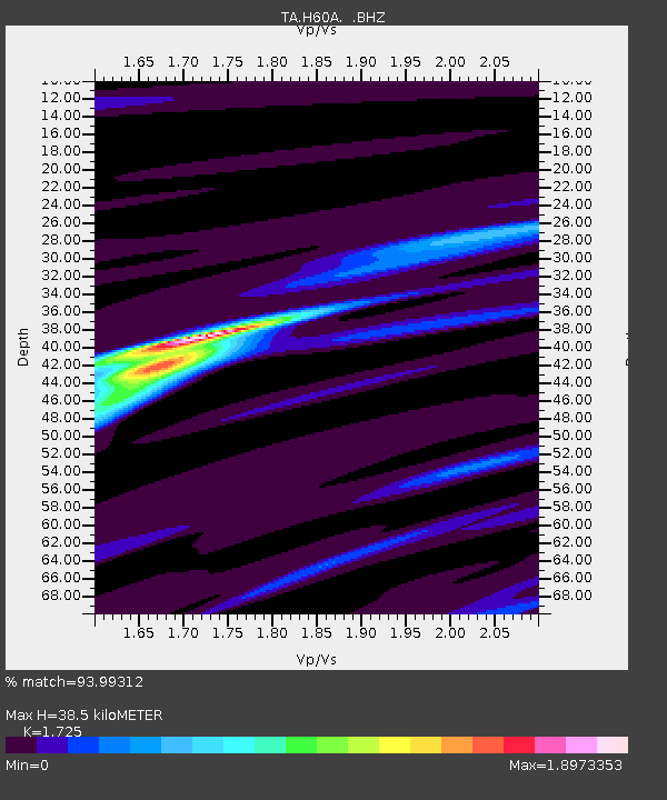
| Estimated Moho Depth: |
38.5 km |
| Estimated Crust Vp/Vs: |
1.73 |
| Assumed Crust Vp: |
6.419 km/s |
| Estimated Crust Vs: |
3.721 km/s |
| Estimated Crust Poisson's Ratio: |
0.25 |
|
| Radial Match: |
93.99312 % |
| Radial Bump: |
180 |
| Transverse Match: |
84.608086 % |
| Transverse Bump: |
400 |
| SOD ConfigId: |
751272 |
| Insert Time: |
2014-07-21 12:12:15.925 +0000 |
| GWidth: |
2.5 |
| Max Bumps: |
400 |
| Tol: |
0.001 |
|

Signal To Noise
| Channel | StoN | STA | LTA |
| TA:H60A: :BHZ:20140707T11:30:04.125007Z | 57.17159 | 7.1790832E-6 | 1.2557082E-7 |
| TA:H60A: :BHN:20140707T11:30:04.125007Z | 24.737902 | 3.8559424E-6 | 1.5587185E-7 |
| TA:H60A: :BHE:20140707T11:30:04.125007Z | 21.453535 | 3.1234842E-6 | 1.4559298E-7 |
| Arrivals |
| Ps | 4.7 SECOND |
| PpPs | 15 SECOND |
| PsPs/PpSs | 20 SECOND |


