You are here: Home > Network List > TA - USArray Transportable Network (new EarthScope stations) Stations List
> Station I51A Listowel, ON, CAN > Earthquake Result Viewer
I51A Listowel, ON, CAN - Earthquake Result Viewer
| Earthquake location: |
Near Coast Of Chiapas, Mexico |
| Earthquake latitude/longitude: |
14.7/-92.4 |
| Earthquake time(UTC): |
2014/07/07 (188) 11:23:55 GMT |
| Earthquake Depth: |
60 km |
| Earthquake Magnitude: |
6.9 MWW, 6.9 MWC, 7.1 MI |
| Earthquake Catalog/Contributor: |
NEIC PDE/NEIC COMCAT |
|
| Network: |
TA USArray Transportable Network (new EarthScope stations) |
| Station: |
I51A Listowel, ON, CAN |
| Lat/Lon: |
43.80 N/81.02 W |
| Elevation: |
376 m |
|
| Distance: |
30.6 deg |
| Az: |
16.33 deg |
| Baz: |
202.068 deg |
| Ray Param: |
0.079217635 |
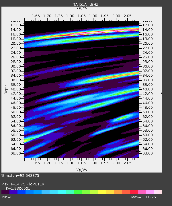
| Estimated Moho Depth: |
14.75 km |
| Estimated Crust Vp/Vs: |
1.93 |
| Assumed Crust Vp: |
6.53 km/s |
| Estimated Crust Vs: |
3.384 km/s |
| Estimated Crust Poisson's Ratio: |
0.32 |
|
| Radial Match: |
92.643875 % |
| Radial Bump: |
400 |
| Transverse Match: |
72.75658 % |
| Transverse Bump: |
400 |
| SOD ConfigId: |
751272 |
| Insert Time: |
2014-07-21 12:12:56.964 +0000 |
| GWidth: |
2.5 |
| Max Bumps: |
400 |
| Tol: |
0.001 |
|
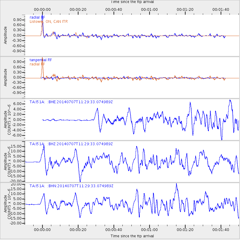
Signal To Noise
| Channel | StoN | STA | LTA |
| TA:I51A: :BHZ:20140707T11:29:33.074989Z | 53.767548 | 8.360959E-6 | 1.5550197E-7 |
| TA:I51A: :BHN:20140707T11:29:33.074989Z | 42.96073 | 6.137263E-6 | 1.428575E-7 |
| TA:I51A: :BHE:20140707T11:29:33.074989Z | 22.367628 | 2.691916E-6 | 1.2034874E-7 |
| Arrivals |
| Ps | 2.3 SECOND |
| PpPs | 6.1 SECOND |
| PsPs/PpSs | 8.4 SECOND |


