You are here: Home > Network List > TA - USArray Transportable Network (new EarthScope stations) Stations List
> Station K55A Perry, NY, USA > Earthquake Result Viewer
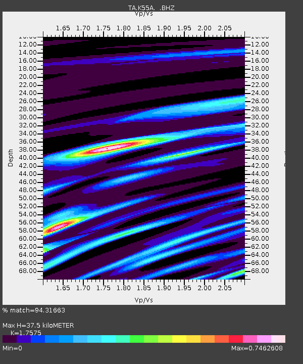
K55A Perry, NY, USA - Earthquake Result Viewer
| Earthquake location: |
Near Coast Of Chiapas, Mexico |
| Earthquake latitude/longitude: |
14.7/-92.4 |
| Earthquake time(UTC): |
2014/07/07 (188) 11:23:55 GMT |
| Earthquake Depth: |
60 km |
| Earthquake Magnitude: |
6.9 MWW, 6.9 MWC, 7.1 MI |
| Earthquake Catalog/Contributor: |
NEIC PDE/NEIC COMCAT |
|
| Network: |
TA USArray Transportable Network (new EarthScope stations) |
| Station: |
K55A Perry, NY, USA |
| Lat/Lon: |
42.73 N/78.07 W |
| Elevation: |
482 m |
|
| Distance: |
30.5 deg |
| Az: |
21.075 deg |
| Baz: |
208.173 deg |
| Ray Param: |
0.07923273 |
| Estimated Moho Depth: |
37.5 km |
| Estimated Crust Vp/Vs: |
1.76 |
| Assumed Crust Vp: |
6.419 km/s |
| Estimated Crust Vs: |
3.652 km/s |
| Estimated Crust Poisson's Ratio: |
0.26 |
|
| Radial Match: |
94.31663 % |
| Radial Bump: |
301 |
| Transverse Match: |
74.07305 % |
| Transverse Bump: |
400 |
| SOD ConfigId: |
751272 |
| Insert Time: |
2014-07-21 12:14:35.521 +0000 |
| GWidth: |
2.5 |
| Max Bumps: |
400 |
| Tol: |
0.001 |
|

Signal To Noise
| Channel | StoN | STA | LTA |
| TA:K55A: :BHZ:20140707T11:29:32.574989Z | 49.069893 | 9.431459E-6 | 1.922046E-7 |
| TA:K55A: :BHN:20140707T11:29:32.574989Z | 44.442825 | 5.6822782E-6 | 1.2785591E-7 |
| TA:K55A: :BHE:20140707T11:29:32.574989Z | 26.155643 | 3.075197E-6 | 1.1757298E-7 |
| Arrivals |
| Ps | 4.8 SECOND |
| PpPs | 15 SECOND |
| PsPs/PpSs | 20 SECOND |


