You are here: Home > Network List > TA - USArray Transportable Network (new EarthScope stations) Stations List
> Station K62A Royalston, MA, USA > Earthquake Result Viewer
K62A Royalston, MA, USA - Earthquake Result Viewer
| Earthquake location: |
Near Coast Of Chiapas, Mexico |
| Earthquake latitude/longitude: |
14.7/-92.4 |
| Earthquake time(UTC): |
2014/07/07 (188) 11:23:55 GMT |
| Earthquake Depth: |
60 km |
| Earthquake Magnitude: |
6.9 MWW, 6.9 MWC, 7.1 MI |
| Earthquake Catalog/Contributor: |
NEIC PDE/NEIC COMCAT |
|
| Network: |
TA USArray Transportable Network (new EarthScope stations) |
| Station: |
K62A Royalston, MA, USA |
| Lat/Lon: |
42.67 N/72.23 W |
| Elevation: |
289 m |
|
| Distance: |
32.8 deg |
| Az: |
28.009 deg |
| Baz: |
218.024 deg |
| Ray Param: |
0.078358606 |
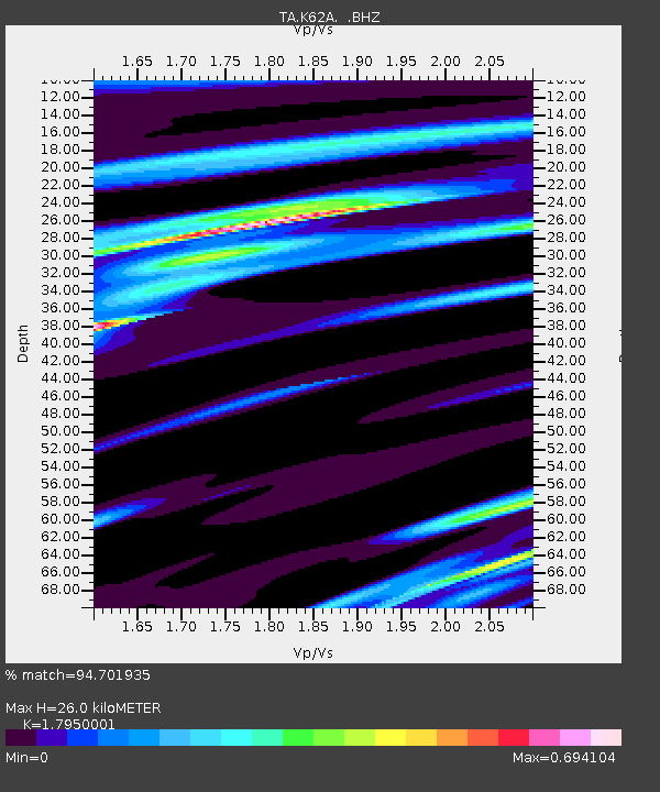
| Estimated Moho Depth: |
26.0 km |
| Estimated Crust Vp/Vs: |
1.80 |
| Assumed Crust Vp: |
6.419 km/s |
| Estimated Crust Vs: |
3.576 km/s |
| Estimated Crust Poisson's Ratio: |
0.27 |
|
| Radial Match: |
94.701935 % |
| Radial Bump: |
268 |
| Transverse Match: |
75.295006 % |
| Transverse Bump: |
400 |
| SOD ConfigId: |
751272 |
| Insert Time: |
2014-07-21 12:14:59.418 +0000 |
| GWidth: |
2.5 |
| Max Bumps: |
400 |
| Tol: |
0.001 |
|
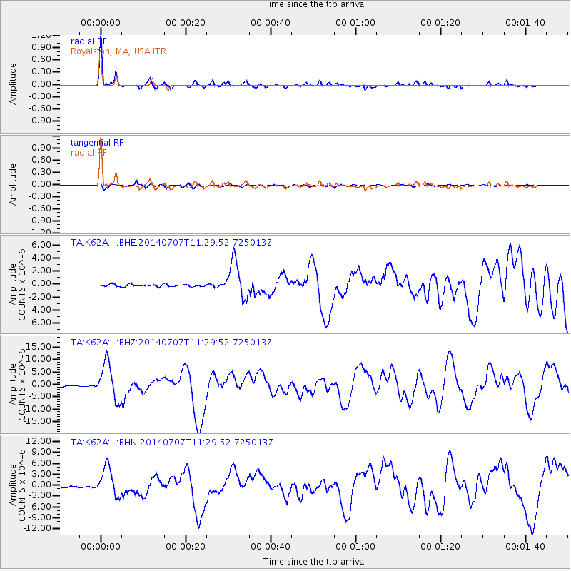
Signal To Noise
| Channel | StoN | STA | LTA |
| TA:K62A: :BHZ:20140707T11:29:52.725013Z | 37.033485 | 7.4679924E-6 | 2.0165513E-7 |
| TA:K62A: :BHN:20140707T11:29:52.725013Z | 25.76986 | 4.0692776E-6 | 1.5790842E-7 |
| TA:K62A: :BHE:20140707T11:29:52.725013Z | 17.159218 | 2.8047752E-6 | 1.634559E-7 |
| Arrivals |
| Ps | 3.5 SECOND |
| PpPs | 10 SECOND |
| PsPs/PpSs | 14 SECOND |


