You are here: Home > Network List > TA - USArray Transportable Network (new EarthScope stations) Stations List
> Station K63A Dunstable, MA, USA > Earthquake Result Viewer
K63A Dunstable, MA, USA - Earthquake Result Viewer

| Earthquake location: |
Near Coast Of Chiapas, Mexico |
| Earthquake latitude/longitude: |
14.7/-92.4 |
| Earthquake time(UTC): |
2014/07/07 (188) 11:23:55 GMT |
| Earthquake Depth: |
60 km |
| Earthquake Magnitude: |
6.9 MWW, 6.9 MWC, 7.1 MI |
| Earthquake Catalog/Contributor: |
NEIC PDE/NEIC COMCAT |
|
| Network: |
TA USArray Transportable Network (new EarthScope stations) |
| Station: |
K63A Dunstable, MA, USA |
| Lat/Lon: |
42.69 N/71.53 W |
| Elevation: |
68 m |
|
| Distance: |
33.1 deg |
| Az: |
28.73 deg |
| Baz: |
219.106 deg |
| Ray Param: |
0.07820064 |
| Estimated Moho Depth: |
26.75 km |
| Estimated Crust Vp/Vs: |
1.81 |
| Assumed Crust Vp: |
6.419 km/s |
| Estimated Crust Vs: |
3.547 km/s |
| Estimated Crust Poisson's Ratio: |
0.28 |
|
| Radial Match: |
94.56669 % |
| Radial Bump: |
238 |
| Transverse Match: |
78.01232 % |
| Transverse Bump: |
400 |
| SOD ConfigId: |
751272 |
| Insert Time: |
2014-07-21 12:15:03.430 +0000 |
| GWidth: |
2.5 |
| Max Bumps: |
400 |
| Tol: |
0.001 |
|
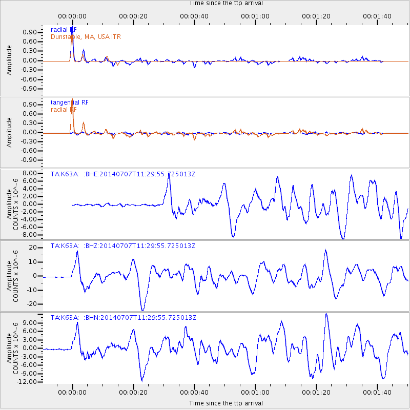
Signal To Noise
| Channel | StoN | STA | LTA |
| TA:K63A: :BHZ:20140707T11:29:55.725013Z | 61.85891 | 8.548641E-6 | 1.381958E-7 |
| TA:K63A: :BHN:20140707T11:29:55.725013Z | 31.115793 | 4.097299E-6 | 1.3167909E-7 |
| TA:K63A: :BHE:20140707T11:29:55.725013Z | 19.435545 | 3.5538758E-6 | 1.8285444E-7 |
| Arrivals |
| Ps | 3.6 SECOND |
| PpPs | 11 SECOND |
| PsPs/PpSs | 14 SECOND |


