You are here: Home > Network List > TA - USArray Transportable Network (new EarthScope stations) Stations List
> Station L59A Walton, NY, USA > Earthquake Result Viewer
L59A Walton, NY, USA - Earthquake Result Viewer
| Earthquake location: |
Near Coast Of Chiapas, Mexico |
| Earthquake latitude/longitude: |
14.7/-92.4 |
| Earthquake time(UTC): |
2014/07/07 (188) 11:23:55 GMT |
| Earthquake Depth: |
60 km |
| Earthquake Magnitude: |
6.9 MWW, 6.9 MWC, 7.1 MI |
| Earthquake Catalog/Contributor: |
NEIC PDE/NEIC COMCAT |
|
| Network: |
TA USArray Transportable Network (new EarthScope stations) |
| Station: |
L59A Walton, NY, USA |
| Lat/Lon: |
42.19 N/75.04 W |
| Elevation: |
677 m |
|
| Distance: |
31.2 deg |
| Az: |
25.359 deg |
| Baz: |
213.888 deg |
| Ray Param: |
0.07904644 |
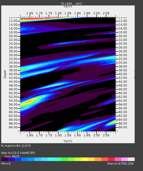
| Estimated Moho Depth: |
10.0 km |
| Estimated Crust Vp/Vs: |
1.66 |
| Assumed Crust Vp: |
6.419 km/s |
| Estimated Crust Vs: |
3.861 km/s |
| Estimated Crust Poisson's Ratio: |
0.22 |
|
| Radial Match: |
94.31074 % |
| Radial Bump: |
362 |
| Transverse Match: |
73.74963 % |
| Transverse Bump: |
400 |
| SOD ConfigId: |
751272 |
| Insert Time: |
2014-07-21 12:15:51.656 +0000 |
| GWidth: |
2.5 |
| Max Bumps: |
400 |
| Tol: |
0.001 |
|
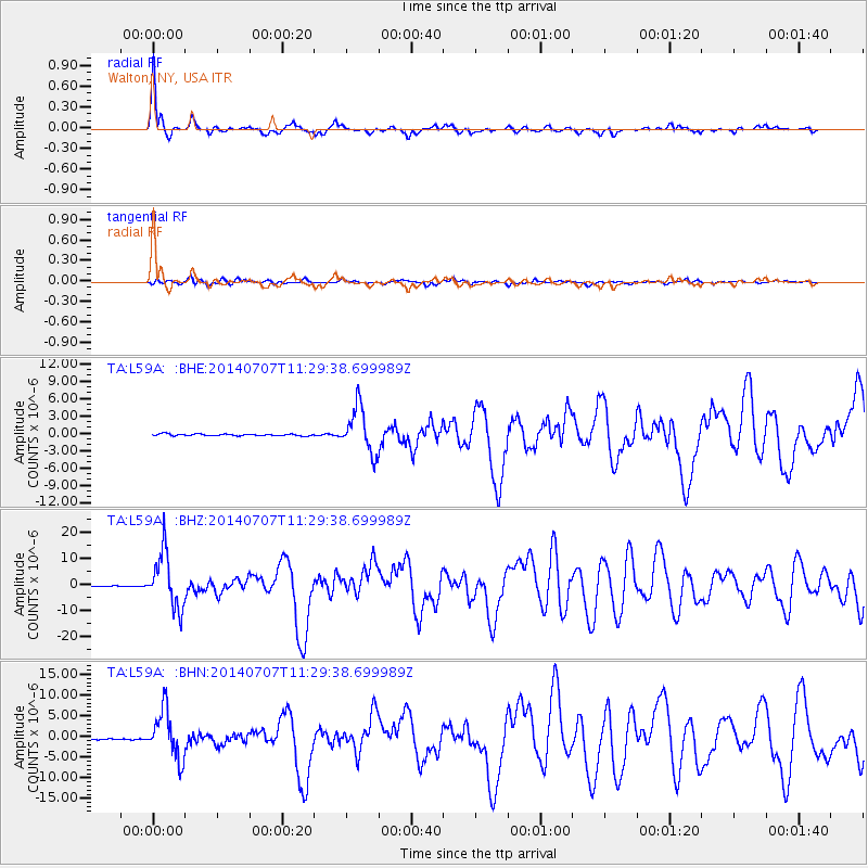
Signal To Noise
| Channel | StoN | STA | LTA |
| TA:L59A: :BHZ:20140707T11:29:38.699989Z | 52.848885 | 1.0532088E-5 | 1.9928686E-7 |
| TA:L59A: :BHN:20140707T11:29:38.699989Z | 37.020084 | 5.8222304E-6 | 1.5727221E-7 |
| TA:L59A: :BHE:20140707T11:29:38.699989Z | 24.431093 | 3.916528E-6 | 1.6030916E-7 |
| Arrivals |
| Ps | 1.1 SECOND |
| PpPs | 3.8 SECOND |
| PsPs/PpSs | 4.9 SECOND |


