You are here: Home > Network List > TA - USArray Transportable Network (new EarthScope stations) Stations List
> Station M62A Hamden, CT, USA > Earthquake Result Viewer
M62A Hamden, CT, USA - Earthquake Result Viewer
| Earthquake location: |
Near Coast Of Chiapas, Mexico |
| Earthquake latitude/longitude: |
14.7/-92.4 |
| Earthquake time(UTC): |
2014/07/07 (188) 11:23:55 GMT |
| Earthquake Depth: |
60 km |
| Earthquake Magnitude: |
6.9 MWW, 6.9 MWC, 7.1 MI |
| Earthquake Catalog/Contributor: |
NEIC PDE/NEIC COMCAT |
|
| Network: |
TA USArray Transportable Network (new EarthScope stations) |
| Station: |
M62A Hamden, CT, USA |
| Lat/Lon: |
41.44 N/72.89 W |
| Elevation: |
24 m |
|
| Distance: |
31.5 deg |
| Az: |
28.699 deg |
| Baz: |
218.168 deg |
| Ray Param: |
0.078902 |
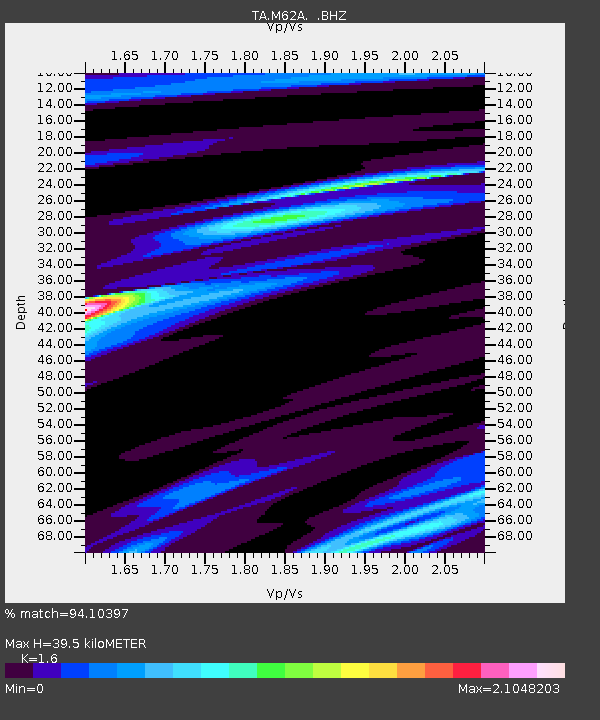
| Estimated Moho Depth: |
39.5 km |
| Estimated Crust Vp/Vs: |
1.60 |
| Assumed Crust Vp: |
6.472 km/s |
| Estimated Crust Vs: |
4.045 km/s |
| Estimated Crust Poisson's Ratio: |
0.18 |
|
| Radial Match: |
94.10397 % |
| Radial Bump: |
202 |
| Transverse Match: |
82.480385 % |
| Transverse Bump: |
400 |
| SOD ConfigId: |
751272 |
| Insert Time: |
2014-07-21 12:16:38.795 +0000 |
| GWidth: |
2.5 |
| Max Bumps: |
400 |
| Tol: |
0.001 |
|

Signal To Noise
| Channel | StoN | STA | LTA |
| TA:M62A: :BHZ:20140707T11:29:41.674995Z | 42.74609 | 8.766064E-6 | 2.0507287E-7 |
| TA:M62A: :BHN:20140707T11:29:41.674995Z | 23.896038 | 4.8024626E-6 | 2.0097318E-7 |
| TA:M62A: :BHE:20140707T11:29:41.674995Z | 28.894827 | 3.5068401E-6 | 1.2136567E-7 |
| Arrivals |
| Ps | 4.0 SECOND |
| PpPs | 15 SECOND |
| PsPs/PpSs | 19 SECOND |


