You are here: Home > Network List > CI - Caltech Regional Seismic Network Stations List
> Station FMP Fort MacArthur Park, Pt. Fermin San Pedro, CA, USA > Earthquake Result Viewer
FMP Fort MacArthur Park, Pt. Fermin San Pedro, CA, USA - Earthquake Result Viewer
| Earthquake location: |
New Britain Region, P.N.G. |
| Earthquake latitude/longitude: |
-5.2/152.6 |
| Earthquake time(UTC): |
2015/03/30 (089) 00:43:15 GMT |
| Earthquake Depth: |
55 km |
| Earthquake Magnitude: |
5.1 mb, 5.0 mb |
| Earthquake Catalog/Contributor: |
ISC/ISC |
|
| Network: |
CI Caltech Regional Seismic Network |
| Station: |
FMP Fort MacArthur Park, Pt. Fermin San Pedro, CA, USA |
| Lat/Lon: |
33.71 N/118.29 W |
| Elevation: |
89 m |
|
| Distance: |
92.1 deg |
| Az: |
56.51 deg |
| Baz: |
265.181 deg |
| Ray Param: |
0.041495178 |
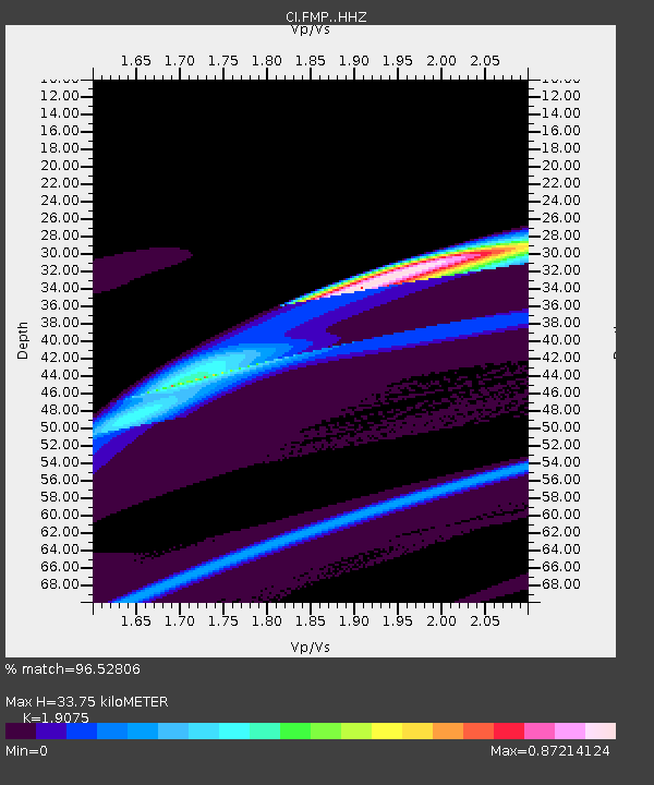
| Estimated Moho Depth: |
33.75 km |
| Estimated Crust Vp/Vs: |
1.91 |
| Assumed Crust Vp: |
6.048 km/s |
| Estimated Crust Vs: |
3.171 km/s |
| Estimated Crust Poisson's Ratio: |
0.31 |
|
| Radial Match: |
96.52806 % |
| Radial Bump: |
350 |
| Transverse Match: |
77.31067 % |
| Transverse Bump: |
361 |
| SOD ConfigId: |
7422571 |
| Insert Time: |
2019-04-17 23:25:44.749 +0000 |
| GWidth: |
2.5 |
| Max Bumps: |
400 |
| Tol: |
0.001 |
|
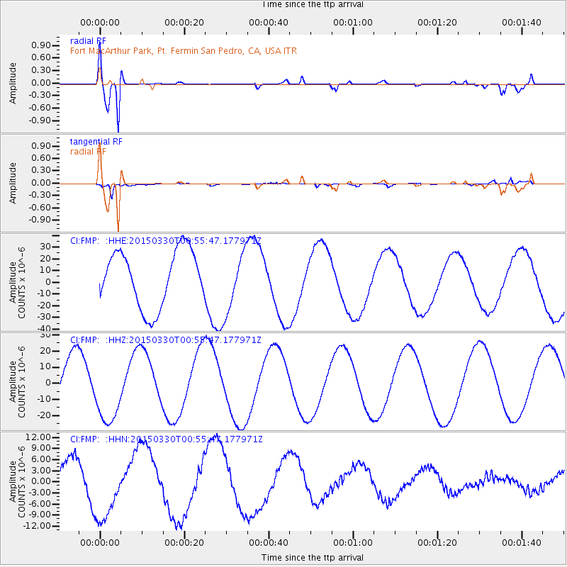
Signal To Noise
| Channel | StoN | STA | LTA |
| CI:FMP: :HHZ:20150330T00:55:47.177971Z | 1.23654 | 2.0096553E-5 | 1.6252248E-5 |
| CI:FMP: :HHN:20150330T00:55:47.177971Z | 2.6213033 | 8.9281075E-6 | 3.4059804E-6 |
| CI:FMP: :HHE:20150330T00:55:47.177971Z | 1.0736775 | 2.5456548E-5 | 2.3709676E-5 |
| Arrivals |
| Ps | 5.2 SECOND |
| PpPs | 16 SECOND |
| PsPs/PpSs | 21 SECOND |


