You are here: Home > Network List > TA - USArray Transportable Network (new EarthScope stations) Stations List
> Station SUSD Miller, SD, USA > Earthquake Result Viewer
SUSD Miller, SD, USA - Earthquake Result Viewer
| Earthquake location: |
Near Coast Of Chiapas, Mexico |
| Earthquake latitude/longitude: |
14.7/-92.4 |
| Earthquake time(UTC): |
2014/07/07 (188) 11:23:55 GMT |
| Earthquake Depth: |
60 km |
| Earthquake Magnitude: |
6.9 MWW, 6.9 MWC, 7.1 MI |
| Earthquake Catalog/Contributor: |
NEIC PDE/NEIC COMCAT |
|
| Network: |
TA USArray Transportable Network (new EarthScope stations) |
| Station: |
SUSD Miller, SD, USA |
| Lat/Lon: |
44.44 N/98.96 W |
| Elevation: |
520 m |
|
| Distance: |
30.1 deg |
| Az: |
350.635 deg |
| Baz: |
167.303 deg |
| Ray Param: |
0.079330996 |
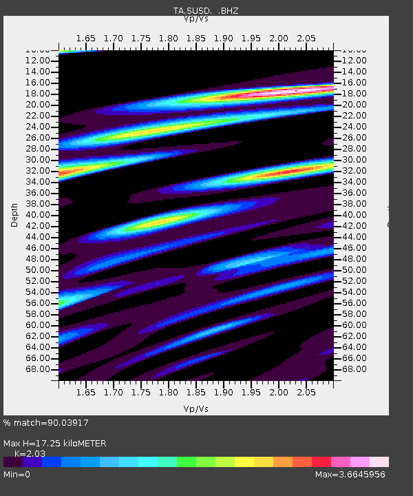
| Estimated Moho Depth: |
17.25 km |
| Estimated Crust Vp/Vs: |
2.03 |
| Assumed Crust Vp: |
6.53 km/s |
| Estimated Crust Vs: |
3.217 km/s |
| Estimated Crust Poisson's Ratio: |
0.34 |
|
| Radial Match: |
90.03917 % |
| Radial Bump: |
317 |
| Transverse Match: |
79.00516 % |
| Transverse Bump: |
390 |
| SOD ConfigId: |
751272 |
| Insert Time: |
2014-07-21 12:17:35.283 +0000 |
| GWidth: |
2.5 |
| Max Bumps: |
400 |
| Tol: |
0.001 |
|

Signal To Noise
| Channel | StoN | STA | LTA |
| TA:SUSD: :BHZ:20140707T11:29:29.275001Z | 48.70629 | 4.3894206E-6 | 9.01202E-8 |
| TA:SUSD: :BHN:20140707T11:29:29.275001Z | 34.85642 | 4.4896933E-6 | 1.2880537E-7 |
| TA:SUSD: :BHE:20140707T11:29:29.275001Z | 10.956443 | 1.1128752E-6 | 1.01572674E-7 |
| Arrivals |
| Ps | 2.9 SECOND |
| PpPs | 7.4 SECOND |
| PsPs/PpSs | 10 SECOND |


