You are here: Home > Network List > UO - University of Oregon Regional Network Stations List
> Station PINE Pine Mountain Observatory, OR > Earthquake Result Viewer
PINE Pine Mountain Observatory, OR - Earthquake Result Viewer
| Earthquake location: |
Near Coast Of Chiapas, Mexico |
| Earthquake latitude/longitude: |
14.7/-92.4 |
| Earthquake time(UTC): |
2014/07/07 (188) 11:23:55 GMT |
| Earthquake Depth: |
60 km |
| Earthquake Magnitude: |
6.9 MWW, 6.9 MWC, 7.1 MI |
| Earthquake Catalog/Contributor: |
NEIC PDE/NEIC COMCAT |
|
| Network: |
UO University of Oregon Regional Network |
| Station: |
PINE Pine Mountain Observatory, OR |
| Lat/Lon: |
43.79 N/120.94 W |
| Elevation: |
1916 m |
|
| Distance: |
37.8 deg |
| Az: |
325.661 deg |
| Baz: |
131.094 deg |
| Ray Param: |
0.07574651 |
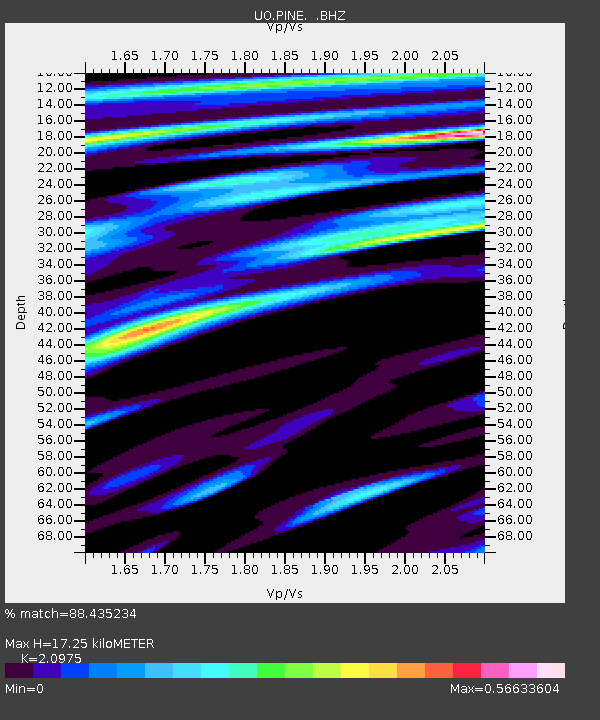
| Estimated Moho Depth: |
17.25 km |
| Estimated Crust Vp/Vs: |
2.10 |
| Assumed Crust Vp: |
6.597 km/s |
| Estimated Crust Vs: |
3.145 km/s |
| Estimated Crust Poisson's Ratio: |
0.35 |
|
| Radial Match: |
88.435234 % |
| Radial Bump: |
400 |
| Transverse Match: |
64.48413 % |
| Transverse Bump: |
400 |
| SOD ConfigId: |
751272 |
| Insert Time: |
2014-07-21 12:18:00.274 +0000 |
| GWidth: |
2.5 |
| Max Bumps: |
400 |
| Tol: |
0.001 |
|

Signal To Noise
| Channel | StoN | STA | LTA |
| UO:PINE: :BHZ:20140707T11:30:35.750007Z | 24.889029 | 2.838284E-6 | 1.1403756E-7 |
| UO:PINE: :BHN:20140707T11:30:35.750007Z | 12.541224 | 1.0911339E-6 | 8.7003784E-8 |
| UO:PINE: :BHE:20140707T11:30:35.750007Z | 11.377628 | 9.625021E-7 | 8.459603E-8 |
| Arrivals |
| Ps | 3.1 SECOND |
| PpPs | 7.6 SECOND |
| PsPs/PpSs | 11 SECOND |


