You are here: Home > Network List > US - United States National Seismic Network Stations List
> Station AHID Auburn Hatchery, Idaho, USA > Earthquake Result Viewer
AHID Auburn Hatchery, Idaho, USA - Earthquake Result Viewer
| Earthquake location: |
Near Coast Of Chiapas, Mexico |
| Earthquake latitude/longitude: |
14.7/-92.4 |
| Earthquake time(UTC): |
2014/07/07 (188) 11:23:55 GMT |
| Earthquake Depth: |
60 km |
| Earthquake Magnitude: |
6.9 MWW, 6.9 MWC, 7.1 MI |
| Earthquake Catalog/Contributor: |
NEIC PDE/NEIC COMCAT |
|
| Network: |
US United States National Seismic Network |
| Station: |
AHID Auburn Hatchery, Idaho, USA |
| Lat/Lon: |
42.77 N/111.10 W |
| Elevation: |
1960 m |
|
| Distance: |
32.2 deg |
| Az: |
333.731 deg |
| Baz: |
144.446 deg |
| Ray Param: |
0.0786092 |
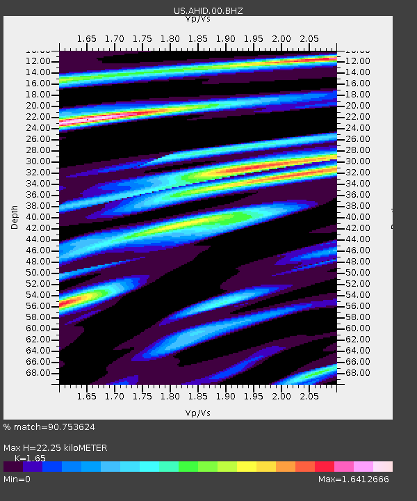
| Estimated Moho Depth: |
22.25 km |
| Estimated Crust Vp/Vs: |
1.65 |
| Assumed Crust Vp: |
6.207 km/s |
| Estimated Crust Vs: |
3.762 km/s |
| Estimated Crust Poisson's Ratio: |
0.21 |
|
| Radial Match: |
90.753624 % |
| Radial Bump: |
400 |
| Transverse Match: |
71.81784 % |
| Transverse Bump: |
400 |
| SOD ConfigId: |
751272 |
| Insert Time: |
2014-07-21 12:18:07.896 +0000 |
| GWidth: |
2.5 |
| Max Bumps: |
400 |
| Tol: |
0.001 |
|
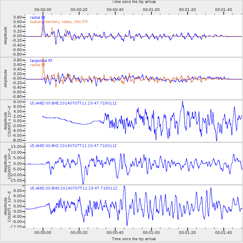
Signal To Noise
| Channel | StoN | STA | LTA |
| US:AHID:00:BHZ:20140707T11:29:47.716011Z | 29.707523 | 2.938218E-6 | 9.890484E-8 |
| US:AHID:00:BHN:20140707T11:29:47.716011Z | 1.2436572 | 1.5827184E-6 | 1.2726322E-6 |
| US:AHID:00:BHE:20140707T11:29:47.716011Z | 0.85775864 | 9.3917015E-7 | 1.0949119E-6 |
| Arrivals |
| Ps | 2.5 SECOND |
| PpPs | 8.8 SECOND |
| PsPs/PpSs | 11 SECOND |


