You are here: Home > Network List > US - United States National Seismic Network Stations List
> Station DGMT Dagmar, Montana, USA > Earthquake Result Viewer
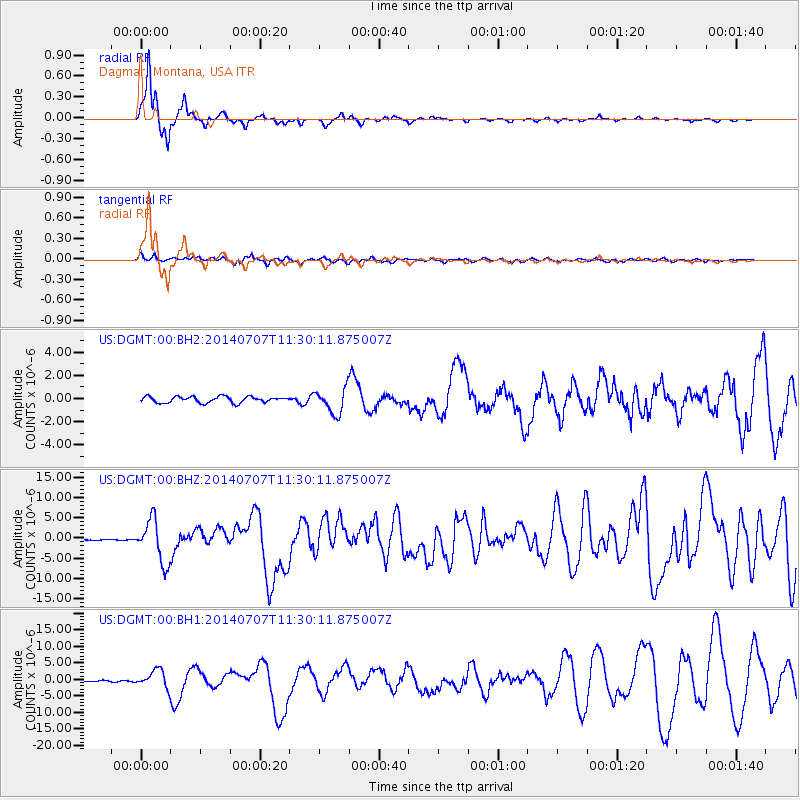
DGMT Dagmar, Montana, USA - Earthquake Result Viewer
*The percent match for this event was below the threshold and hence no stack was calculated.
| Earthquake location: |
Near Coast Of Chiapas, Mexico |
| Earthquake latitude/longitude: |
14.7/-92.4 |
| Earthquake time(UTC): |
2014/07/07 (188) 11:23:55 GMT |
| Earthquake Depth: |
60 km |
| Earthquake Magnitude: |
6.9 MWW, 6.9 MWC, 7.1 MI |
| Earthquake Catalog/Contributor: |
NEIC PDE/NEIC COMCAT |
|
| Network: |
US United States National Seismic Network |
| Station: |
DGMT Dagmar, Montana, USA |
| Lat/Lon: |
48.47 N/104.20 W |
| Elevation: |
0.0 m |
|
| Distance: |
35.0 deg |
| Az: |
346.294 deg |
| Baz: |
159.852 deg |
| Ray Param: |
$rayparam |
*The percent match for this event was below the threshold and hence was not used in the summary stack. |
|
| Radial Match: |
96.96032 % |
| Radial Bump: |
248 |
| Transverse Match: |
78.59366 % |
| Transverse Bump: |
400 |
| SOD ConfigId: |
751272 |
| Insert Time: |
2014-07-21 12:18:29.438 +0000 |
| GWidth: |
2.5 |
| Max Bumps: |
400 |
| Tol: |
0.001 |
|
Signal To Noise
| Channel | StoN | STA | LTA |
| US:DGMT:00:BHZ:20140707T11:30:11.875007Z | 65.95411 | 5.2433993E-6 | 7.9500715E-8 |
| US:DGMT:00:BH1:20140707T11:30:11.875007Z | 13.658524 | 2.6273963E-6 | 1.9236312E-7 |
| US:DGMT:00:BH2:20140707T11:30:11.875007Z | 4.073793 | 1.0746924E-6 | 2.6380633E-7 |
| Arrivals |
| Ps | |
| PpPs | |
| PsPs/PpSs | |


