You are here: Home > Network List > TA - USArray Transportable Network (new EarthScope stations) Stations List
> Station L04D Klamath Falls, OR, USA > Earthquake Result Viewer
L04D Klamath Falls, OR, USA - Earthquake Result Viewer
| Earthquake location: |
New Britain Region, P.N.G. |
| Earthquake latitude/longitude: |
-5.2/152.6 |
| Earthquake time(UTC): |
2015/03/30 (089) 00:43:15 GMT |
| Earthquake Depth: |
55 km |
| Earthquake Magnitude: |
5.1 mb, 5.0 mb |
| Earthquake Catalog/Contributor: |
ISC/ISC |
|
| Network: |
TA USArray Transportable Network (new EarthScope stations) |
| Station: |
L04D Klamath Falls, OR, USA |
| Lat/Lon: |
42.22 N/122.30 W |
| Elevation: |
1437 m |
|
| Distance: |
89.8 deg |
| Az: |
47.737 deg |
| Baz: |
262.859 deg |
| Ray Param: |
0.041710395 |
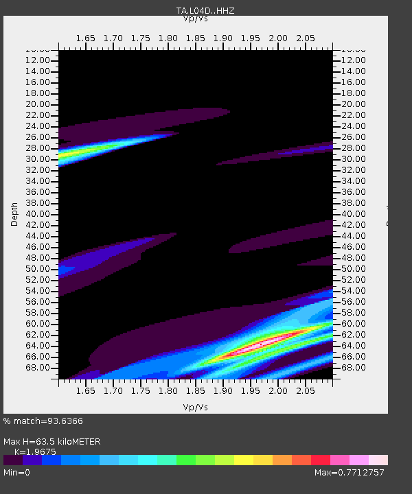
| Estimated Moho Depth: |
63.5 km |
| Estimated Crust Vp/Vs: |
1.97 |
| Assumed Crust Vp: |
6.522 km/s |
| Estimated Crust Vs: |
3.315 km/s |
| Estimated Crust Poisson's Ratio: |
0.33 |
|
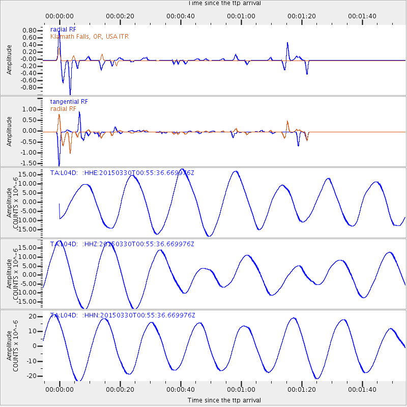
| Radial Match: |
93.6366 % |
| Radial Bump: |
400 |
| Transverse Match: |
93.34559 % |
| Transverse Bump: |
216 |
| SOD ConfigId: |
7422571 |
| Insert Time: |
2019-04-17 23:27:33.170 +0000 |
| GWidth: |
2.5 |
| Max Bumps: |
400 |
| Tol: |
0.001 |
|
Signal To Noise
| Channel | StoN | STA | LTA |
| TA:L04D: :HHZ:20150330T00:55:36.669976Z | 1.6591165 | 1.5507372E-5 | 9.346765E-6 |
| TA:L04D: :HHN:20150330T00:55:36.669976Z | 1.1482749 | 1.3720123E-5 | 1.1948466E-5 |
| TA:L04D: :HHE:20150330T00:55:36.669976Z | 1.5291097 | 1.3838656E-5 | 9.050139E-6 |
| Arrivals |
| Ps | 9.6 SECOND |
| PpPs | 28 SECOND |
| PsPs/PpSs | 38 SECOND |


