You are here: Home > Network List > US - United States National Seismic Network Stations List
> Station LONY Lake Ozonia, New York, USA > Earthquake Result Viewer
LONY Lake Ozonia, New York, USA - Earthquake Result Viewer
| Earthquake location: |
Near Coast Of Chiapas, Mexico |
| Earthquake latitude/longitude: |
14.7/-92.4 |
| Earthquake time(UTC): |
2014/07/07 (188) 11:23:55 GMT |
| Earthquake Depth: |
60 km |
| Earthquake Magnitude: |
6.9 MWW, 6.9 MWC, 7.1 MI |
| Earthquake Catalog/Contributor: |
NEIC PDE/NEIC COMCAT |
|
| Network: |
US United States National Seismic Network |
| Station: |
LONY Lake Ozonia, New York, USA |
| Lat/Lon: |
44.62 N/74.58 W |
| Elevation: |
440 m |
|
| Distance: |
33.4 deg |
| Az: |
23.394 deg |
| Baz: |
212.542 deg |
| Ray Param: |
0.07807794 |
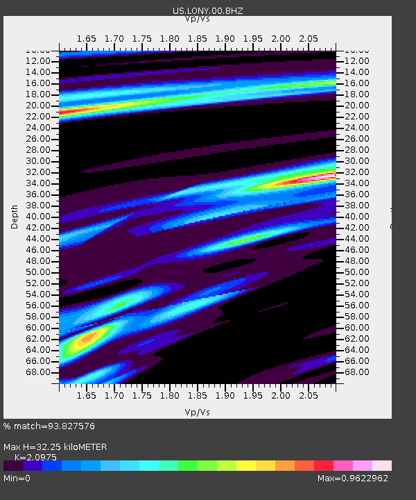
| Estimated Moho Depth: |
32.25 km |
| Estimated Crust Vp/Vs: |
2.10 |
| Assumed Crust Vp: |
6.419 km/s |
| Estimated Crust Vs: |
3.06 km/s |
| Estimated Crust Poisson's Ratio: |
0.35 |
|
| Radial Match: |
93.827576 % |
| Radial Bump: |
244 |
| Transverse Match: |
91.44302 % |
| Transverse Bump: |
274 |
| SOD ConfigId: |
751272 |
| Insert Time: |
2014-07-21 12:19:11.183 +0000 |
| GWidth: |
2.5 |
| Max Bumps: |
400 |
| Tol: |
0.001 |
|
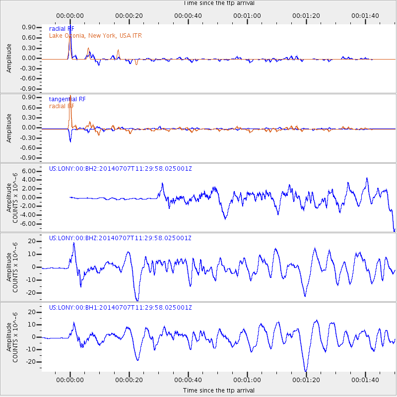
Signal To Noise
| Channel | StoN | STA | LTA |
| US:LONY:00:BHZ:20140707T11:29:58.025001Z | 50.613457 | 8.878117E-6 | 1.7541022E-7 |
| US:LONY:00:BH1:20140707T11:29:58.025001Z | 31.24155 | 5.46123E-6 | 1.7480663E-7 |
| US:LONY:00:BH2:20140707T11:29:58.025001Z | 9.810977 | 1.3304061E-6 | 1.3560384E-7 |
| Arrivals |
| Ps | 5.9 SECOND |
| PpPs | 15 SECOND |
| PsPs/PpSs | 20 SECOND |


