You are here: Home > Network List > UW - Pacific Northwest Regional Seismic Network Stations List
> Station LCCR Mulino, OR, USA > Earthquake Result Viewer
LCCR Mulino, OR, USA - Earthquake Result Viewer
| Earthquake location: |
Near Coast Of Chiapas, Mexico |
| Earthquake latitude/longitude: |
14.7/-92.4 |
| Earthquake time(UTC): |
2014/07/07 (188) 11:23:55 GMT |
| Earthquake Depth: |
60 km |
| Earthquake Magnitude: |
6.9 MWW, 6.9 MWC, 7.1 MI |
| Earthquake Catalog/Contributor: |
NEIC PDE/NEIC COMCAT |
|
| Network: |
UW Pacific Northwest Regional Seismic Network |
| Station: |
LCCR Mulino, OR, USA |
| Lat/Lon: |
45.21 N/122.48 W |
| Elevation: |
273 m |
|
| Distance: |
39.6 deg |
| Az: |
326.223 deg |
| Baz: |
130.459 deg |
| Ray Param: |
0.07473105 |
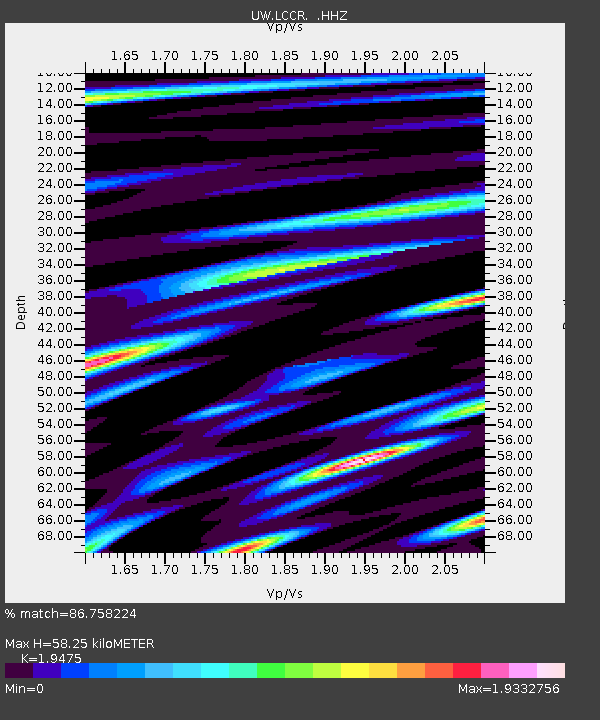
| Estimated Moho Depth: |
58.25 km |
| Estimated Crust Vp/Vs: |
1.95 |
| Assumed Crust Vp: |
6.566 km/s |
| Estimated Crust Vs: |
3.372 km/s |
| Estimated Crust Poisson's Ratio: |
0.32 |
|
| Radial Match: |
86.758224 % |
| Radial Bump: |
400 |
| Transverse Match: |
82.54172 % |
| Transverse Bump: |
400 |
| SOD ConfigId: |
751272 |
| Insert Time: |
2014-07-21 12:21:35.666 +0000 |
| GWidth: |
2.5 |
| Max Bumps: |
400 |
| Tol: |
0.001 |
|

Signal To Noise
| Channel | StoN | STA | LTA |
| UW:LCCR: :HHZ:20140707T11:30:50.427986Z | 55.90534 | 5.8378796E-6 | 1.04424366E-7 |
| UW:LCCR: :HHN:20140707T11:30:50.427986Z | 10.778736 | 2.1510618E-6 | 1.9956532E-7 |
| UW:LCCR: :HHE:20140707T11:30:50.427986Z | 12.063788 | 2.0449052E-6 | 1.6950771E-7 |
| Arrivals |
| Ps | 9.0 SECOND |
| PpPs | 24 SECOND |
| PsPs/PpSs | 33 SECOND |


